You are here: Home > Network List > TA - USArray Transportable Network (new EarthScope stations) Stations List
> Station I16A Newdale, ID, USA > Earthquake Result Viewer
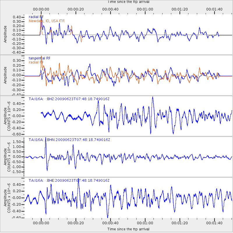
I16A Newdale, ID, USA - Earthquake Result Viewer
*The percent match for this event was below the threshold and hence no stack was calculated.
| Earthquake location: |
Near East Coast Of Honshu, Japan |
| Earthquake latitude/longitude: |
38.8/142.4 |
| Earthquake time(UTC): |
2009/06/23 (174) 07:37:17 GMT |
| Earthquake Depth: |
37 km |
| Earthquake Magnitude: |
5.7 MB, 5.0 MS, 5.6 MW, 5.6 MW |
| Earthquake Catalog/Contributor: |
WHDF/NEIC |
|
| Network: |
TA USArray Transportable Network (new EarthScope stations) |
| Station: |
I16A Newdale, ID, USA |
| Lat/Lon: |
43.88 N/111.49 W |
| Elevation: |
1744 m |
|
| Distance: |
74.1 deg |
| Az: |
46.262 deg |
| Baz: |
308.728 deg |
| Ray Param: |
$rayparam |
*The percent match for this event was below the threshold and hence was not used in the summary stack. |
|
| Radial Match: |
64.376495 % |
| Radial Bump: |
400 |
| Transverse Match: |
72.13425 % |
| Transverse Bump: |
400 |
| SOD ConfigId: |
2648 |
| Insert Time: |
2010-03-06 09:04:31.197 +0000 |
| GWidth: |
2.5 |
| Max Bumps: |
400 |
| Tol: |
0.001 |
|
Signal To Noise
| Channel | StoN | STA | LTA |
| TA:I16A: :BHN:20090623T07:48:18.749016Z | 11.441174 | 6.733798E-7 | 5.8855832E-8 |
| TA:I16A: :BHE:20090623T07:48:18.749016Z | 2.0718713 | 1.7959552E-7 | 8.668276E-8 |
| TA:I16A: :BHZ:20090623T07:48:18.749016Z | 2.7815404 | 2.3531234E-7 | 8.459786E-8 |
| Arrivals |
| Ps | |
| PpPs | |
| PsPs/PpSs | |


