You are here: Home > Network List > TA - USArray Transportable Network (new EarthScope stations) Stations List
> Station I16A Newdale, ID, USA > Earthquake Result Viewer
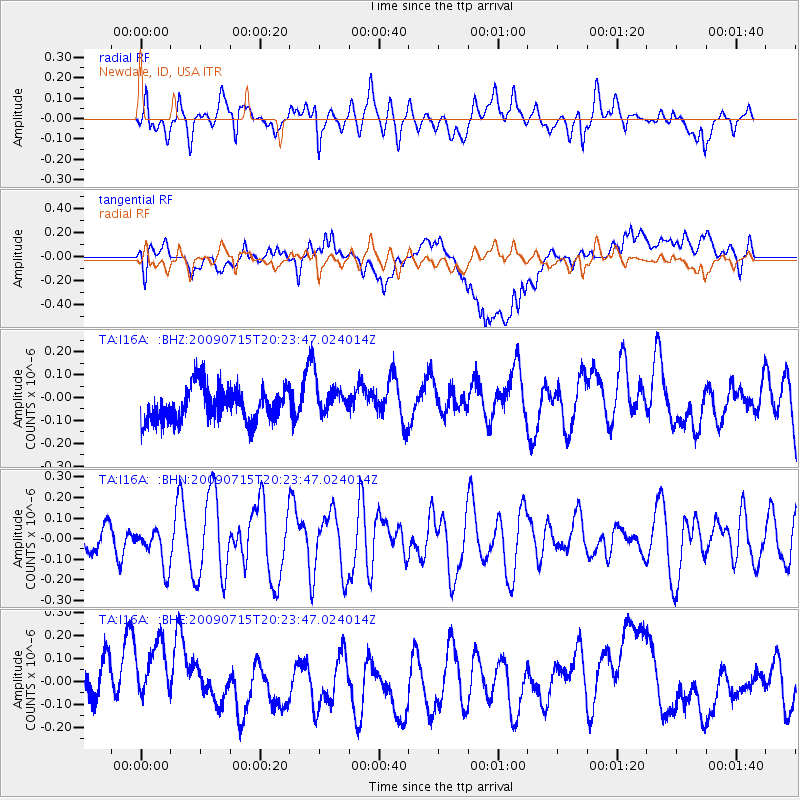
I16A Newdale, ID, USA - Earthquake Result Viewer
*The percent match for this event was below the threshold and hence no stack was calculated.
| Earthquake location: |
New Ireland Region, P.N.G. |
| Earthquake latitude/longitude: |
-3.4/150.5 |
| Earthquake time(UTC): |
2009/07/15 (196) 20:10:42 GMT |
| Earthquake Depth: |
13 km |
| Earthquake Magnitude: |
5.6 MB, 6.1 MS, 6.1 MW, 6.1 MW |
| Earthquake Catalog/Contributor: |
WHDF/NEIC |
|
| Network: |
TA USArray Transportable Network (new EarthScope stations) |
| Station: |
I16A Newdale, ID, USA |
| Lat/Lon: |
43.88 N/111.49 W |
| Elevation: |
1744 m |
|
| Distance: |
98.1 deg |
| Az: |
46.331 deg |
| Baz: |
273.113 deg |
| Ray Param: |
$rayparam |
*The percent match for this event was below the threshold and hence was not used in the summary stack. |
|
| Radial Match: |
53.956627 % |
| Radial Bump: |
400 |
| Transverse Match: |
60.979652 % |
| Transverse Bump: |
400 |
| SOD ConfigId: |
2648 |
| Insert Time: |
2010-03-06 09:04:36.410 +0000 |
| GWidth: |
2.5 |
| Max Bumps: |
400 |
| Tol: |
0.001 |
|
Signal To Noise
| Channel | StoN | STA | LTA |
| TA:I16A: :BHN:20090715T20:23:47.024014Z | 1.3609464 | 9.2392845E-8 | 6.788867E-8 |
| TA:I16A: :BHE:20090715T20:23:47.024014Z | 1.1773161 | 1.8868967E-7 | 1.6027104E-7 |
| TA:I16A: :BHZ:20090715T20:23:47.024014Z | 0.9816066 | 7.1818846E-8 | 7.316459E-8 |
| Arrivals |
| Ps | |
| PpPs | |
| PsPs/PpSs | |


