You are here: Home > Network List > TA - USArray Transportable Network (new EarthScope stations) Stations List
> Station I23K Minto, Yukon-Koyukuk, AK, USA > Earthquake Result Viewer
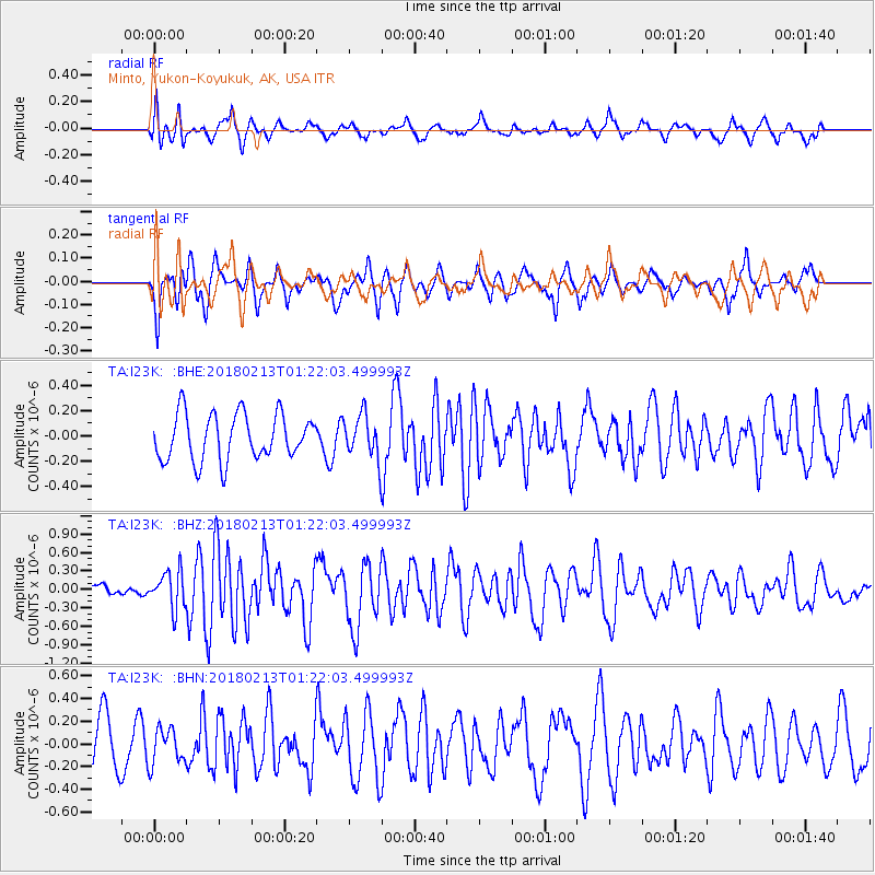
I23K Minto, Yukon-Koyukuk, AK, USA - Earthquake Result Viewer
*The percent match for this event was below the threshold and hence no stack was calculated.
| Earthquake location: |
South Of Mariana Islands |
| Earthquake latitude/longitude: |
13.9/146.4 |
| Earthquake time(UTC): |
2018/02/13 (044) 01:11:43 GMT |
| Earthquake Depth: |
12 km |
| Earthquake Magnitude: |
5.4 mb |
| Earthquake Catalog/Contributor: |
NEIC PDE/us |
|
| Network: |
TA USArray Transportable Network (new EarthScope stations) |
| Station: |
I23K Minto, Yukon-Koyukuk, AK, USA |
| Lat/Lon: |
65.15 N/149.36 W |
| Elevation: |
149 m |
|
| Distance: |
66.8 deg |
| Az: |
24.462 deg |
| Baz: |
252.125 deg |
| Ray Param: |
$rayparam |
*The percent match for this event was below the threshold and hence was not used in the summary stack. |
|
| Radial Match: |
53.961678 % |
| Radial Bump: |
400 |
| Transverse Match: |
51.339863 % |
| Transverse Bump: |
384 |
| SOD ConfigId: |
13570011 |
| Insert Time: |
2019-04-29 19:39:12.883 +0000 |
| GWidth: |
2.5 |
| Max Bumps: |
400 |
| Tol: |
0.001 |
|
Signal To Noise
| Channel | StoN | STA | LTA |
| TA:I23K: :BHZ:20180213T01:22:03.499993Z | 2.3991137 | 3.0214682E-7 | 1.2594103E-7 |
| TA:I23K: :BHN:20180213T01:22:03.499993Z | 0.7031841 | 1.5653062E-7 | 2.226026E-7 |
| TA:I23K: :BHE:20180213T01:22:03.499993Z | 0.94134796 | 1.7086727E-7 | 1.815134E-7 |
| Arrivals |
| Ps | |
| PpPs | |
| PsPs/PpSs | |


