You are here: Home > Network List > TA - USArray Transportable Network (new EarthScope stations) Stations List
> Station O17K Koliganek, Bristol Bay, AK, USA > Earthquake Result Viewer
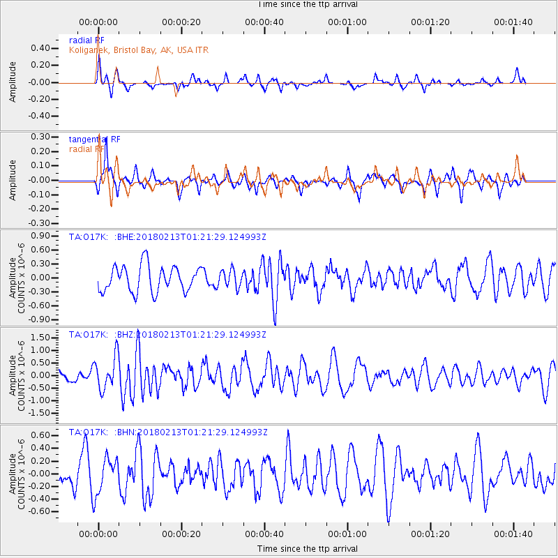
O17K Koliganek, Bristol Bay, AK, USA - Earthquake Result Viewer
*The percent match for this event was below the threshold and hence no stack was calculated.
| Earthquake location: |
South Of Mariana Islands |
| Earthquake latitude/longitude: |
13.9/146.4 |
| Earthquake time(UTC): |
2018/02/13 (044) 01:11:43 GMT |
| Earthquake Depth: |
12 km |
| Earthquake Magnitude: |
5.4 mb |
| Earthquake Catalog/Contributor: |
NEIC PDE/us |
|
| Network: |
TA USArray Transportable Network (new EarthScope stations) |
| Station: |
O17K Koliganek, Bristol Bay, AK, USA |
| Lat/Lon: |
59.77 N/157.09 W |
| Elevation: |
156 m |
|
| Distance: |
61.5 deg |
| Az: |
28.677 deg |
| Baz: |
247.106 deg |
| Ray Param: |
$rayparam |
*The percent match for this event was below the threshold and hence was not used in the summary stack. |
|
| Radial Match: |
57.867508 % |
| Radial Bump: |
338 |
| Transverse Match: |
63.64431 % |
| Transverse Bump: |
288 |
| SOD ConfigId: |
13570011 |
| Insert Time: |
2019-04-29 19:39:24.430 +0000 |
| GWidth: |
2.5 |
| Max Bumps: |
400 |
| Tol: |
0.001 |
|
Signal To Noise
| Channel | StoN | STA | LTA |
| TA:O17K: :BHZ:20180213T01:21:29.124993Z | 3.082137 | 6.726577E-7 | 2.1824393E-7 |
| TA:O17K: :BHN:20180213T01:21:29.124993Z | 1.2967743 | 2.6699658E-7 | 2.0589287E-7 |
| TA:O17K: :BHE:20180213T01:21:29.124993Z | 0.6567773 | 1.8302164E-7 | 2.786662E-7 |
| Arrivals |
| Ps | |
| PpPs | |
| PsPs/PpSs | |


