You are here: Home > Network List > UW - Pacific Northwest Regional Seismic Network Stations List
> Station LEBA Lebam, WA, USA > Earthquake Result Viewer
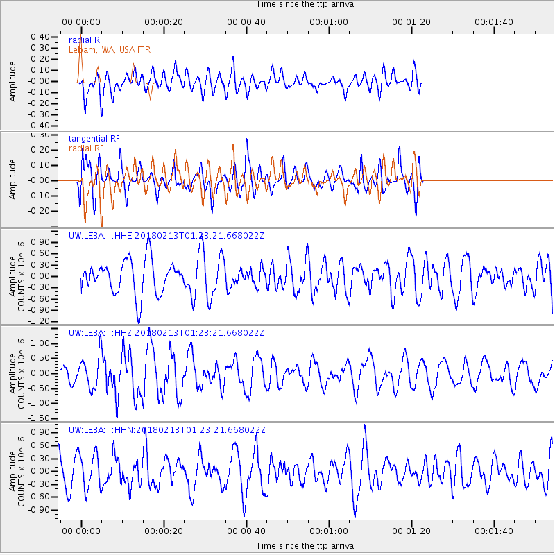
LEBA Lebam, WA, USA - Earthquake Result Viewer
*The percent match for this event was below the threshold and hence no stack was calculated.
| Earthquake location: |
South Of Mariana Islands |
| Earthquake latitude/longitude: |
13.9/146.4 |
| Earthquake time(UTC): |
2018/02/13 (044) 01:11:43 GMT |
| Earthquake Depth: |
12 km |
| Earthquake Magnitude: |
5.4 mb |
| Earthquake Catalog/Contributor: |
NEIC PDE/us |
|
| Network: |
UW Pacific Northwest Regional Seismic Network |
| Station: |
LEBA Lebam, WA, USA |
| Lat/Lon: |
46.55 N/123.56 W |
| Elevation: |
73 m |
|
| Distance: |
80.1 deg |
| Az: |
44.476 deg |
| Baz: |
279.618 deg |
| Ray Param: |
$rayparam |
*The percent match for this event was below the threshold and hence was not used in the summary stack. |
|
| Radial Match: |
34.495502 % |
| Radial Bump: |
377 |
| Transverse Match: |
59.731636 % |
| Transverse Bump: |
400 |
| SOD ConfigId: |
13570011 |
| Insert Time: |
2019-04-29 19:39:53.697 +0000 |
| GWidth: |
2.5 |
| Max Bumps: |
400 |
| Tol: |
0.001 |
|
Signal To Noise
| Channel | StoN | STA | LTA |
| UW:LEBA: :HHZ:20180213T01:23:21.668022Z | 2.1747496 | 5.2935195E-7 | 2.4340824E-7 |
| UW:LEBA: :HHN:20180213T01:23:21.668022Z | 0.9061005 | 4.169286E-7 | 4.6013503E-7 |
| UW:LEBA: :HHE:20180213T01:23:21.668022Z | 1.4409883 | 6.364923E-7 | 4.417054E-7 |
| Arrivals |
| Ps | |
| PpPs | |
| PsPs/PpSs | |


