You are here: Home > Network List > TA - USArray Transportable Network (new EarthScope stations) Stations List
> Station I16A Newdale, ID, USA > Earthquake Result Viewer
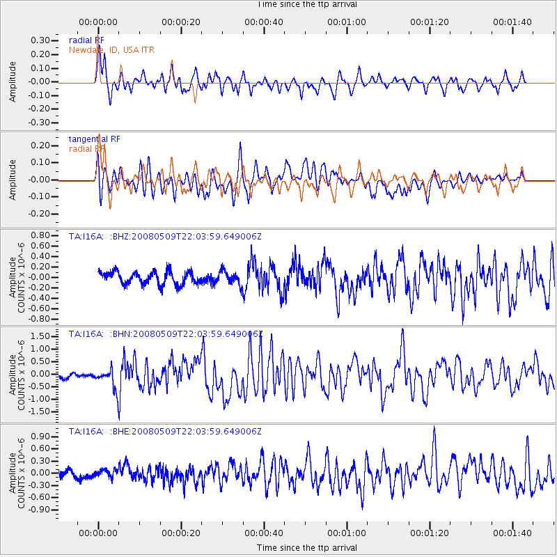
I16A Newdale, ID, USA - Earthquake Result Viewer
*The percent match for this event was below the threshold and hence no stack was calculated.
| Earthquake location: |
South Of Mariana Islands |
| Earthquake latitude/longitude: |
12.5/143.2 |
| Earthquake time(UTC): |
2008/05/09 (130) 21:51:29 GMT |
| Earthquake Depth: |
76 km |
| Earthquake Magnitude: |
6.1 MB, 6.7 MW, 6.7 MW |
| Earthquake Catalog/Contributor: |
WHDF/NEIC |
|
| Network: |
TA USArray Transportable Network (new EarthScope stations) |
| Station: |
I16A Newdale, ID, USA |
| Lat/Lon: |
43.88 N/111.49 W |
| Elevation: |
1744 m |
|
| Distance: |
92.2 deg |
| Az: |
44.261 deg |
| Baz: |
289.53 deg |
| Ray Param: |
$rayparam |
*The percent match for this event was below the threshold and hence was not used in the summary stack. |
|
| Radial Match: |
82.019806 % |
| Radial Bump: |
400 |
| Transverse Match: |
76.002075 % |
| Transverse Bump: |
400 |
| SOD ConfigId: |
2504 |
| Insert Time: |
2010-03-06 09:04:57.417 +0000 |
| GWidth: |
2.5 |
| Max Bumps: |
400 |
| Tol: |
0.001 |
|
Signal To Noise
| Channel | StoN | STA | LTA |
| TA:I16A: :BHN:20080509T22:03:59.649006Z | 4.4729376 | 4.0760636E-7 | 9.112722E-8 |
| TA:I16A: :BHE:20080509T22:03:59.649006Z | 0.7680338 | 9.431996E-8 | 1.2280705E-7 |
| TA:I16A: :BHZ:20080509T22:03:59.649006Z | 1.0927625 | 1.3162777E-7 | 1.2045415E-7 |
| Arrivals |
| Ps | |
| PpPs | |
| PsPs/PpSs | |


