You are here: Home > Network List > TA - USArray Transportable Network (new EarthScope stations) Stations List
> Station I16A Newdale, ID, USA > Earthquake Result Viewer
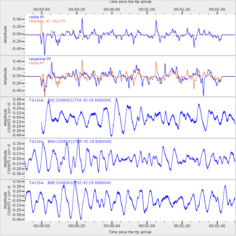
I16A Newdale, ID, USA - Earthquake Result Viewer
*The percent match for this event was below the threshold and hence no stack was calculated.
| Earthquake location: |
Southern East Pacific Rise |
| Earthquake latitude/longitude: |
-50.2/-114.2 |
| Earthquake time(UTC): |
2008/06/12 (164) 05:30:43 GMT |
| Earthquake Depth: |
10 km |
| Earthquake Magnitude: |
5.6 MS, 5.3 MB, 5.9 MW, 5.9 MW |
| Earthquake Catalog/Contributor: |
WHDF/NEIC |
|
| Network: |
TA USArray Transportable Network (new EarthScope stations) |
| Station: |
I16A Newdale, ID, USA |
| Lat/Lon: |
43.88 N/111.49 W |
| Elevation: |
1744 m |
|
| Distance: |
93.7 deg |
| Az: |
1.943 deg |
| Baz: |
181.728 deg |
| Ray Param: |
$rayparam |
*The percent match for this event was below the threshold and hence was not used in the summary stack. |
|
| Radial Match: |
59.324837 % |
| Radial Bump: |
400 |
| Transverse Match: |
73.013245 % |
| Transverse Bump: |
400 |
| SOD ConfigId: |
2504 |
| Insert Time: |
2010-03-06 09:05:10.445 +0000 |
| GWidth: |
2.5 |
| Max Bumps: |
400 |
| Tol: |
0.001 |
|
Signal To Noise
| Channel | StoN | STA | LTA |
| TA:I16A: :BHN:20080612T05:43:28.898994Z | 1.9112065 | 1.9546836E-7 | 1.0227485E-7 |
| TA:I16A: :BHE:20080612T05:43:28.898994Z | 1.0199764 | 1.4210478E-7 | 1.3932164E-7 |
| TA:I16A: :BHZ:20080612T05:43:28.898994Z | 0.89579743 | 1.2066285E-7 | 1.3469881E-7 |
| Arrivals |
| Ps | |
| PpPs | |
| PsPs/PpSs | |


