You are here: Home > Network List > CI - Caltech Regional Seismic Network Stations List
> Station TIN Tinemaha, Big Pine, CA, USA > Earthquake Result Viewer
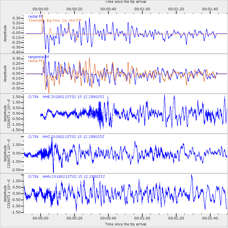
TIN Tinemaha, Big Pine, CA, USA - Earthquake Result Viewer
*The percent match for this event was below the threshold and hence no stack was calculated.
| Earthquake location: |
South Of Mariana Islands |
| Earthquake latitude/longitude: |
13.8/146.7 |
| Earthquake time(UTC): |
2018/02/13 (044) 02:03:03 GMT |
| Earthquake Depth: |
10 km |
| Earthquake Magnitude: |
5.7 mww |
| Earthquake Catalog/Contributor: |
NEIC PDE/pt |
|
| Network: |
CI Caltech Regional Seismic Network |
| Station: |
TIN Tinemaha, Big Pine, CA, USA |
| Lat/Lon: |
37.05 N/118.23 W |
| Elevation: |
1197 m |
|
| Distance: |
85.8 deg |
| Az: |
53.033 deg |
| Baz: |
284.049 deg |
| Ray Param: |
$rayparam |
*The percent match for this event was below the threshold and hence was not used in the summary stack. |
|
| Radial Match: |
73.032394 % |
| Radial Bump: |
400 |
| Transverse Match: |
64.340195 % |
| Transverse Bump: |
400 |
| SOD ConfigId: |
13570011 |
| Insert Time: |
2019-04-29 19:42:42.077 +0000 |
| GWidth: |
2.5 |
| Max Bumps: |
400 |
| Tol: |
0.001 |
|
Signal To Noise
| Channel | StoN | STA | LTA |
| CI:TIN: :HHZ:20180213T02:15:12.288025Z | 2.2897978 | 3.8516683E-7 | 1.6820998E-7 |
| CI:TIN: :HHN:20180213T02:15:12.288025Z | 1.1037984 | 2.7993477E-7 | 2.536104E-7 |
| CI:TIN: :HHE:20180213T02:15:12.288025Z | 1.4570197 | 2.9771817E-7 | 2.0433366E-7 |
| Arrivals |
| Ps | |
| PpPs | |
| PsPs/PpSs | |


