You are here: Home > Network List > IW - Intermountain West Stations List
> Station MOOW Moose Ponds, Wyoming, USA > Earthquake Result Viewer
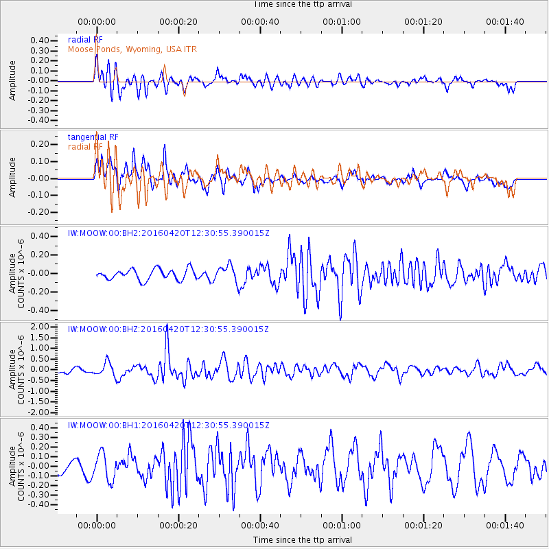
MOOW Moose Ponds, Wyoming, USA - Earthquake Result Viewer
*The percent match for this event was below the threshold and hence no stack was calculated.
| Earthquake location: |
Near East Coast Of Honshu, Japan |
| Earthquake latitude/longitude: |
37.8/141.6 |
| Earthquake time(UTC): |
2016/04/20 (111) 12:19:45 GMT |
| Earthquake Depth: |
41 km |
| Earthquake Magnitude: |
5.8 MB |
| Earthquake Catalog/Contributor: |
NEIC PDE/NEIC ALERT |
|
| Network: |
IW Intermountain West |
| Station: |
MOOW Moose Ponds, Wyoming, USA |
| Lat/Lon: |
43.75 N/110.74 W |
| Elevation: |
2128 m |
|
| Distance: |
75.7 deg |
| Az: |
45.44 deg |
| Baz: |
308.857 deg |
| Ray Param: |
$rayparam |
*The percent match for this event was below the threshold and hence was not used in the summary stack. |
|
| Radial Match: |
74.82774 % |
| Radial Bump: |
400 |
| Transverse Match: |
66.95665 % |
| Transverse Bump: |
400 |
| SOD ConfigId: |
1475611 |
| Insert Time: |
2016-05-04 12:24:44.764 +0000 |
| GWidth: |
2.5 |
| Max Bumps: |
400 |
| Tol: |
0.001 |
|
Signal To Noise
| Channel | StoN | STA | LTA |
| IW:MOOW:00:BHZ:20160420T12:30:55.390015Z | 2.750353 | 3.2307418E-7 | 1.1746644E-7 |
| IW:MOOW:00:BH1:20160420T12:30:55.390015Z | 1.1751783 | 1.4081527E-7 | 1.1982459E-7 |
| IW:MOOW:00:BH2:20160420T12:30:55.390015Z | 1.643718 | 9.3709346E-8 | 5.70106E-8 |
| Arrivals |
| Ps | |
| PpPs | |
| PsPs/PpSs | |


