You are here: Home > Network List > TA - USArray Transportable Network (new EarthScope stations) Stations List
> Station I16A Newdale, ID, USA > Earthquake Result Viewer
I16A Newdale, ID, USA - Earthquake Result Viewer
*The percent match for this event was below the threshold and hence no stack was calculated.
| Earthquake location: |
Vanuatu Islands |
| Earthquake latitude/longitude: |
-14.9/168.1 |
| Earthquake time(UTC): |
2008/11/07 (312) 09:40:00 GMT |
| Earthquake Depth: |
10 km |
| Earthquake Magnitude: |
5.5 MB, 4.9 MS, 5.5 MW |
| Earthquake Catalog/Contributor: |
WHDF/NEIC |
|
| Network: |
TA USArray Transportable Network (new EarthScope stations) |
| Station: |
I16A Newdale, ID, USA |
| Lat/Lon: |
43.88 N/111.49 W |
| Elevation: |
1744 m |
|
| Distance: |
93.4 deg |
| Az: |
45.587 deg |
| Baz: |
252.72 deg |
| Ray Param: |
$rayparam |
*The percent match for this event was below the threshold and hence was not used in the summary stack. |
|
| Radial Match: |
69.97419 % |
| Radial Bump: |
400 |
| Transverse Match: |
54.957973 % |
| Transverse Bump: |
400 |
| SOD ConfigId: |
2658 |
| Insert Time: |
2010-03-06 09:05:46.571 +0000 |
| GWidth: |
2.5 |
| Max Bumps: |
400 |
| Tol: |
0.001 |
|
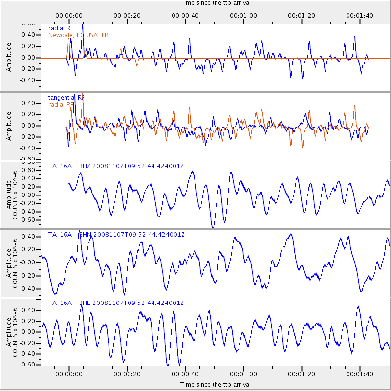
Signal To Noise
| Channel | StoN | STA | LTA |
| TA:I16A: :BHN:20081107T09:52:44.424001Z | 0.87852776 | 2.0024216E-7 | 2.2792923E-7 |
| TA:I16A: :BHE:20081107T09:52:44.424001Z | 1.3444371 | 2.7458313E-7 | 2.0423649E-7 |
| TA:I16A: :BHZ:20081107T09:52:44.424001Z | 1.3893664 | 3.217522E-7 | 2.3158196E-7 |
| Arrivals |
| Ps | |
| PpPs | |
| PsPs/PpSs | |


