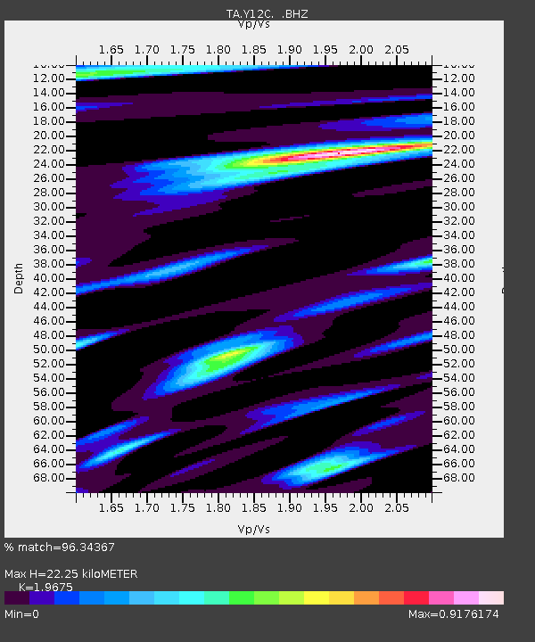
Y12C Blythe, CA, USA - Earthquake Result Viewer

Earthquake location: Kermadec Islands, New Zealand
Earthquake latitude/longitude: -29.8/-177.7
Earthquake time(UTC): 2008/09/29 (273) 15:19:31 GMT
Earthquake Depth: 36 km
Earthquake Magnitude: 6.5 MB, 6.7 MS, 7.0 MW, 7.0 MW
Earthquake Catalog/Contributor: WHDF/NEIC
Network: TA USArray Transportable Network (new EarthScope stations)
Station: Y12C Blythe, CA, USA
Lat/Lon: 33.75 N/114.52 W
Elevation: 196 m
Distance: 86.9 deg
Az: 48.117 deg
Baz: 230.989 deg
Ray Param: 0.0436645
Estimated Moho Depth: 22.25 km
Estimated Crust Vp/Vs: 1.97
Assumed Crust Vp: 6.155 km/s
Estimated Crust Vs: 3.128 km/s
Estimated Crust Poisson's Ratio: 0.33
Radial Match: 96.34367 %
Radial Bump: 400
Transverse Match: 90.860985 %
Transverse Bump: 400
SOD ConfigId: 2560
Insert Time: 2010-03-06 09:06:06.640 +0000
GWidth: 2.5
Max Bumps: 400
Tol: 0.001

Signal To Noise

ChannelStoNSTALTA
TA:Y12C: :BHZ:20080929T15:31:41.470005Z6.65934047.049407E-71.0585744E-7
TA:Y12C: :BHN:20080929T15:31:41.470005Z2.42463061.613577E-76.65494E-8
TA:Y12C: :BHE:20080929T15:31:41.470005Z2.26072671.6443487E-77.273541E-8
Arrivals
Ps3.6 SECOND
PpPs11 SECOND
PsPs/PpSs14 SECOND