You are here: Home > Network List > US - United States National Seismic Network Stations List
> Station AMTX Amarillo, Texas, USA > Earthquake Result Viewer
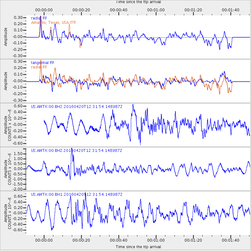
AMTX Amarillo, Texas, USA - Earthquake Result Viewer
*The percent match for this event was below the threshold and hence no stack was calculated.
| Earthquake location: |
Near East Coast Of Honshu, Japan |
| Earthquake latitude/longitude: |
37.8/141.6 |
| Earthquake time(UTC): |
2016/04/20 (111) 12:19:45 GMT |
| Earthquake Depth: |
41 km |
| Earthquake Magnitude: |
5.8 MB |
| Earthquake Catalog/Contributor: |
NEIC PDE/NEIC ALERT |
|
| Network: |
US United States National Seismic Network |
| Station: |
AMTX Amarillo, Texas, USA |
| Lat/Lon: |
34.53 N/101.41 W |
| Elevation: |
1010 m |
|
| Distance: |
87.3 deg |
| Az: |
47.43 deg |
| Baz: |
315.049 deg |
| Ray Param: |
$rayparam |
*The percent match for this event was below the threshold and hence was not used in the summary stack. |
|
| Radial Match: |
37.238186 % |
| Radial Bump: |
400 |
| Transverse Match: |
51.328087 % |
| Transverse Bump: |
400 |
| SOD ConfigId: |
1475611 |
| Insert Time: |
2016-05-04 12:26:09.977 +0000 |
| GWidth: |
2.5 |
| Max Bumps: |
400 |
| Tol: |
0.001 |
|
Signal To Noise
| Channel | StoN | STA | LTA |
| US:AMTX:00:BHZ:20160420T12:31:54.148987Z | 1.8843287 | 4.2720924E-7 | 2.2671695E-7 |
| US:AMTX:00:BH1:20160420T12:31:54.148987Z | 1.1381279 | 3.4628107E-7 | 3.0425497E-7 |
| US:AMTX:00:BH2:20160420T12:31:54.148987Z | 1.5188221 | 2.6666427E-7 | 1.7557308E-7 |
| Arrivals |
| Ps | |
| PpPs | |
| PsPs/PpSs | |


