You are here: Home > Network List > TA - USArray Transportable Network (new EarthScope stations) Stations List
> Station B18K Kokolik River, AK, USA > Earthquake Result Viewer
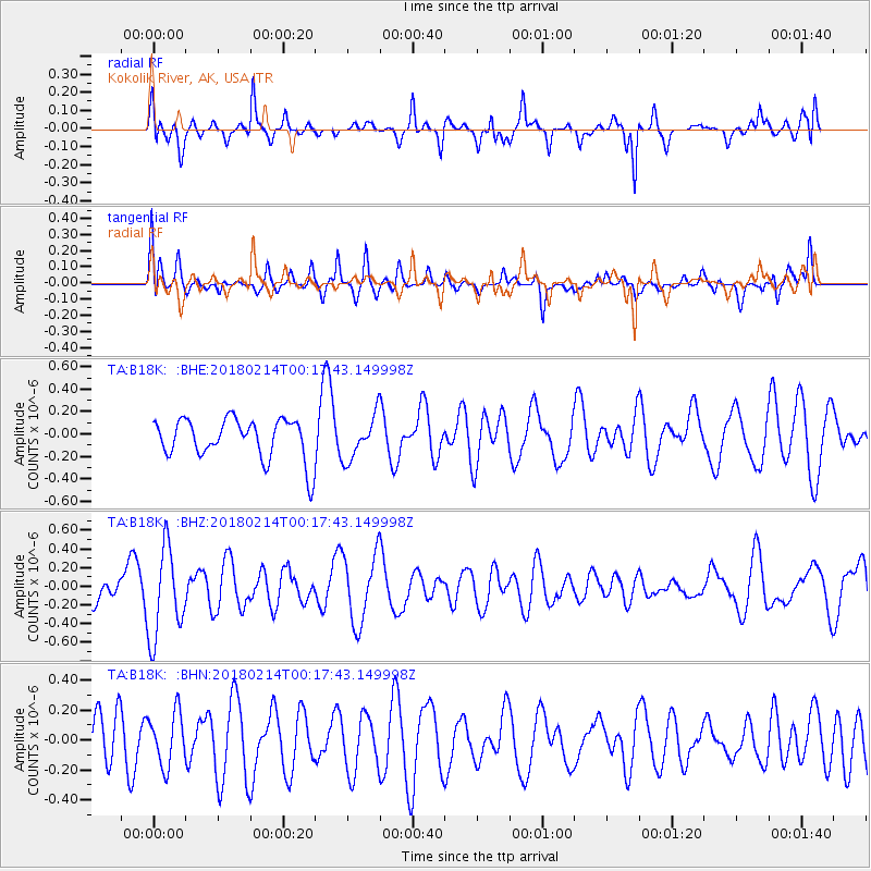
B18K Kokolik River, AK, USA - Earthquake Result Viewer
*The percent match for this event was below the threshold and hence no stack was calculated.
| Earthquake location: |
Aru Islands Region, Indonesia |
| Earthquake latitude/longitude: |
-6.0/133.8 |
| Earthquake time(UTC): |
2018/02/14 (045) 00:05:30 GMT |
| Earthquake Depth: |
10 km |
| Earthquake Magnitude: |
5.5 mb |
| Earthquake Catalog/Contributor: |
NEIC PDE/us |
|
| Network: |
TA USArray Transportable Network (new EarthScope stations) |
| Station: |
B18K Kokolik River, AK, USA |
| Lat/Lon: |
69.36 N/161.80 W |
| Elevation: |
222 m |
|
| Distance: |
86.8 deg |
| Az: |
18.674 deg |
| Baz: |
243.936 deg |
| Ray Param: |
$rayparam |
*The percent match for this event was below the threshold and hence was not used in the summary stack. |
|
| Radial Match: |
60.589737 % |
| Radial Bump: |
370 |
| Transverse Match: |
42.359097 % |
| Transverse Bump: |
336 |
| SOD ConfigId: |
13570011 |
| Insert Time: |
2019-04-29 19:56:21.109 +0000 |
| GWidth: |
2.5 |
| Max Bumps: |
400 |
| Tol: |
0.001 |
|
Signal To Noise
| Channel | StoN | STA | LTA |
| TA:B18K: :BHZ:20180214T00:17:43.149998Z | 2.4162 | 4.8182005E-7 | 1.9941233E-7 |
| TA:B18K: :BHN:20180214T00:17:43.149998Z | 0.70091707 | 1.7610091E-7 | 2.512436E-7 |
| TA:B18K: :BHE:20180214T00:17:43.149998Z | 1.1147518 | 2.017772E-7 | 1.8100638E-7 |
| Arrivals |
| Ps | |
| PpPs | |
| PsPs/PpSs | |


