You are here: Home > Network List > TA - USArray Transportable Network (new EarthScope stations) Stations List
> Station Y12C Blythe, CA, USA > Earthquake Result Viewer
Y12C Blythe, CA, USA - Earthquake Result Viewer

| Earthquake location: |
Mariana Islands |
| Earthquake latitude/longitude: |
16.0/145.9 |
| Earthquake time(UTC): |
2005/02/05 (036) 03:34:25 GMT |
| Earthquake Depth: |
143 km |
| Earthquake Magnitude: |
6.3 MB, 6.6 MW, 6.5 MW |
| Earthquake Catalog/Contributor: |
WHDF/NEIC |
|
| Network: |
TA USArray Transportable Network (new EarthScope stations) |
| Station: |
Y12C Blythe, CA, USA |
| Lat/Lon: |
33.75 N/114.52 W |
| Elevation: |
196 m |
|
| Distance: |
89.0 deg |
| Az: |
55.248 deg |
| Baz: |
288.494 deg |
| Ray Param: |
0.04187995 |
| Estimated Moho Depth: |
26.0 km |
| Estimated Crust Vp/Vs: |
1.78 |
| Assumed Crust Vp: |
6.155 km/s |
| Estimated Crust Vs: |
3.462 km/s |
| Estimated Crust Poisson's Ratio: |
0.27 |
|
| Radial Match: |
87.88438 % |
| Radial Bump: |
400 |
| Transverse Match: |
81.15684 % |
| Transverse Bump: |
400 |
| SOD ConfigId: |
5233 |
| Insert Time: |
2010-03-06 09:06:45.097 +0000 |
| GWidth: |
2.5 |
| Max Bumps: |
400 |
| Tol: |
0.001 |
|
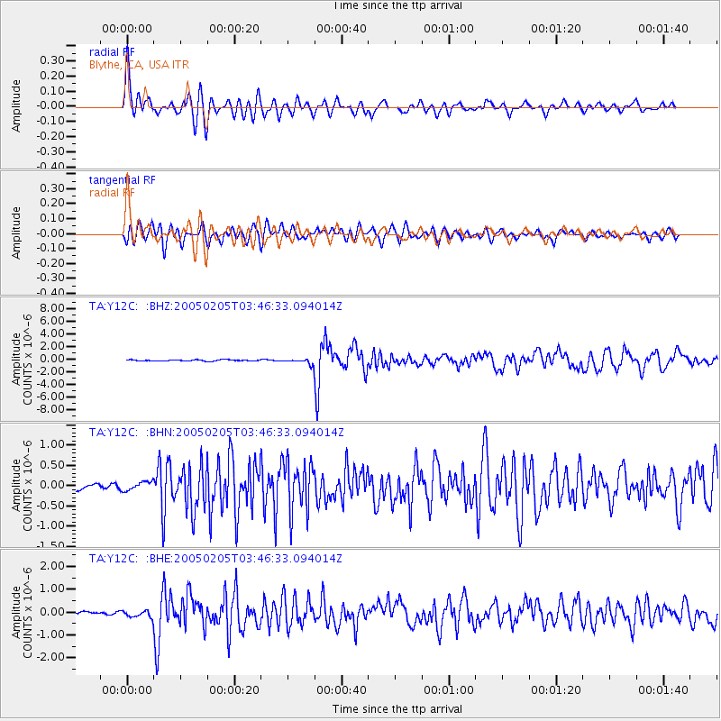
Signal To Noise
| Channel | StoN | STA | LTA |
| TA:Y12C: :BHN:20050205T03:46:33.094014Z | 1.5039403 | 1.1167111E-7 | 7.425236E-8 |
| TA:Y12C: :BHE:20050205T03:46:33.094014Z | 1.1718023 | 1.4255339E-7 | 1.2165312E-7 |
| TA:Y12C: :BHZ:20050205T03:46:33.094014Z | 4.8379445 | 4.2402147E-7 | 8.7644956E-8 |
| Arrivals |
| Ps | 3.3 SECOND |
| PpPs | 12 SECOND |
| PsPs/PpSs | 15 SECOND |


