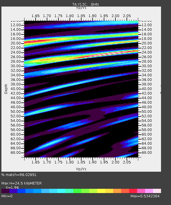
Y12C Blythe, CA, USA - Earthquake Result Viewer

Earthquake location: Off East Coast Of Honshu, Japan
Earthquake latitude/longitude: 38.1/144.9
Earthquake time(UTC): 2005/11/14 (318) 21:38:51 GMT
Earthquake Depth: 11 km
Earthquake Magnitude: 6.7 MB, 6.8 MS, 7.0 MW, 6.9 MW
Earthquake Catalog/Contributor: WHDF/NEIC
Network: TA USArray Transportable Network (new EarthScope stations)
Station: Y12C Blythe, CA, USA
Lat/Lon: 33.75 N/114.52 W
Elevation: 196 m
Distance: 77.3 deg
Az: 57.08 deg
Baz: 307.366 deg
Ray Param: 0.05038735
Estimated Moho Depth: 24.5 km
Estimated Crust Vp/Vs: 1.96
Assumed Crust Vp: 6.155 km/s
Estimated Crust Vs: 3.14 km/s
Estimated Crust Poisson's Ratio: 0.32
Radial Match: 96.02651 %
Radial Bump: 400
Transverse Match: 87.22005 %
Transverse Bump: 400
SOD ConfigId: 2448
Insert Time: 2010-03-06 09:07:30.566 +0000
GWidth: 2.5
Max Bumps: 400
Tol: 0.001

Signal To Noise

ChannelStoNSTALTA
TA:Y12C: :BHN:20051114T21:50:14.695024Z5.085694.7225475E-79.285952E-8
TA:Y12C: :BHE:20051114T21:50:14.695024Z2.63030895.3772897E-72.0443568E-7
TA:Y12C: :BHZ:20051114T21:50:14.695024Z6.7517861.7161556E-62.5417802E-7
Arrivals
Ps3.9 SECOND
PpPs11 SECOND
PsPs/PpSs15 SECOND