You are here: Home > Network List > TA - USArray Transportable Network (new EarthScope stations) Stations List
> Station Y12C Blythe, CA, USA > Earthquake Result Viewer
Y12C Blythe, CA, USA - Earthquake Result Viewer

| Earthquake location: |
Panama-Costa Rica Border Region |
| Earthquake latitude/longitude: |
8.4/-82.9 |
| Earthquake time(UTC): |
2005/06/30 (181) 21:26:36 GMT |
| Earthquake Depth: |
38 km |
| Earthquake Magnitude: |
5.3 MB, 5.6 MS, 6.0 MW, 5.8 MW |
| Earthquake Catalog/Contributor: |
WHDF/NEIC |
|
| Network: |
TA USArray Transportable Network (new EarthScope stations) |
| Station: |
Y12C Blythe, CA, USA |
| Lat/Lon: |
33.75 N/114.52 W |
| Elevation: |
196 m |
|
| Distance: |
38.5 deg |
| Az: |
315.414 deg |
| Baz: |
123.54 deg |
| Ray Param: |
0.07543299 |
| Estimated Moho Depth: |
20.5 km |
| Estimated Crust Vp/Vs: |
1.87 |
| Assumed Crust Vp: |
6.155 km/s |
| Estimated Crust Vs: |
3.287 km/s |
| Estimated Crust Poisson's Ratio: |
0.30 |
|
| Radial Match: |
94.59402 % |
| Radial Bump: |
400 |
| Transverse Match: |
84.401794 % |
| Transverse Bump: |
400 |
| SOD ConfigId: |
142937 |
| Insert Time: |
2010-03-06 09:07:33.154 +0000 |
| GWidth: |
2.5 |
| Max Bumps: |
400 |
| Tol: |
0.001 |
|
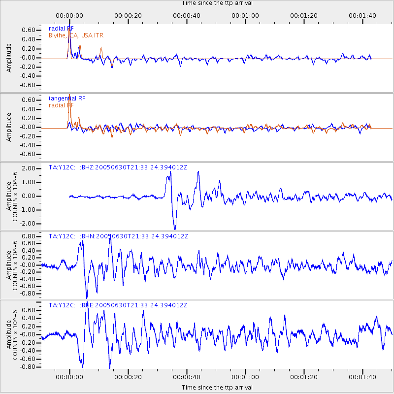
Signal To Noise
| Channel | StoN | STA | LTA |
| TA:Y12C: :BHN:20050630T21:33:24.394012Z | 7.7812986 | 3.284947E-7 | 4.2215923E-8 |
| TA:Y12C: :BHE:20050630T21:33:24.394012Z | 6.7920876 | 3.4786433E-7 | 5.1216112E-8 |
| TA:Y12C: :BHZ:20050630T21:33:24.394012Z | 13.392282 | 8.099542E-7 | 6.047918E-8 |
| Arrivals |
| Ps | 3.1 SECOND |
| PpPs | 9.0 SECOND |
| PsPs/PpSs | 12 SECOND |


