You are here: Home > Network List > TA - USArray Transportable Network (new EarthScope stations) Stations List
> Station Y12C Blythe, CA, USA > Earthquake Result Viewer
Y12C Blythe, CA, USA - Earthquake Result Viewer
| Earthquake location: |
South Of Kermadec Islands |
| Earthquake latitude/longitude: |
-32.6/-179.4 |
| Earthquake time(UTC): |
2005/05/16 (136) 03:54:14 GMT |
| Earthquake Depth: |
34 km |
| Earthquake Magnitude: |
6.2 MB, 6.4 MS, 6.6 MW, 6.6 MW |
| Earthquake Catalog/Contributor: |
WHDF/NEIC |
|
| Network: |
TA USArray Transportable Network (new EarthScope stations) |
| Station: |
Y12C Blythe, CA, USA |
| Lat/Lon: |
33.75 N/114.52 W |
| Elevation: |
196 m |
|
| Distance: |
89.8 deg |
| Az: |
48.944 deg |
| Baz: |
229.821 deg |
| Ray Param: |
0.041711595 |
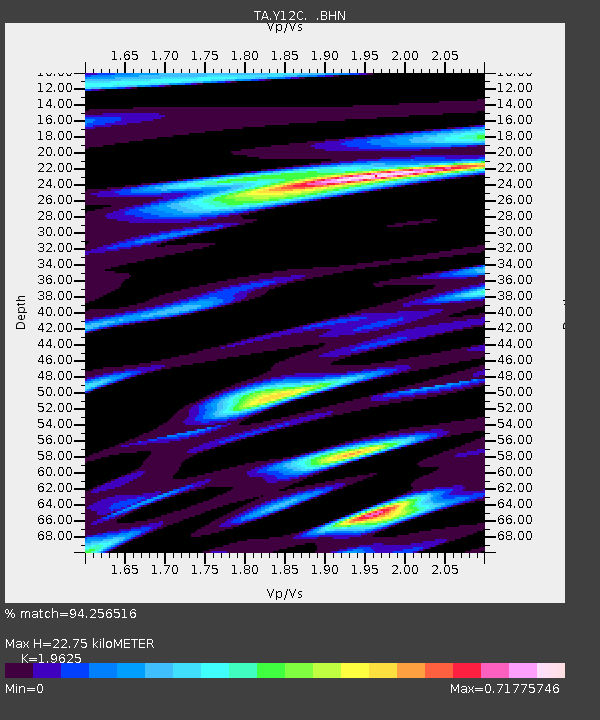
| Estimated Moho Depth: |
22.75 km |
| Estimated Crust Vp/Vs: |
1.96 |
| Assumed Crust Vp: |
6.155 km/s |
| Estimated Crust Vs: |
3.136 km/s |
| Estimated Crust Poisson's Ratio: |
0.32 |
|
| Radial Match: |
94.256516 % |
| Radial Bump: |
400 |
| Transverse Match: |
85.88697 % |
| Transverse Bump: |
400 |
| SOD ConfigId: |
142939 |
| Insert Time: |
2010-03-06 09:07:42.070 +0000 |
| GWidth: |
2.5 |
| Max Bumps: |
400 |
| Tol: |
0.001 |
|

Signal To Noise
| Channel | StoN | STA | LTA |
| TA:Y12C: :BHN:20050516T04:06:38.645024Z | 3.8232436 | 2.3095858E-7 | 6.0409064E-8 |
| TA:Y12C: :BHE:20050516T04:06:38.645024Z | 2.8236573 | 3.0004335E-7 | 1.0626054E-7 |
| TA:Y12C: :BHZ:20050516T04:06:38.645024Z | 10.205147 | 1.2620268E-6 | 1.2366571E-7 |
| Arrivals |
| Ps | 3.6 SECOND |
| PpPs | 11 SECOND |
| PsPs/PpSs | 14 SECOND |


