You are here: Home > Network List > WY - Yellowstone Wyoming Seismic Network Stations List
> Station YUF Upper Falls, WY, USA > Earthquake Result Viewer
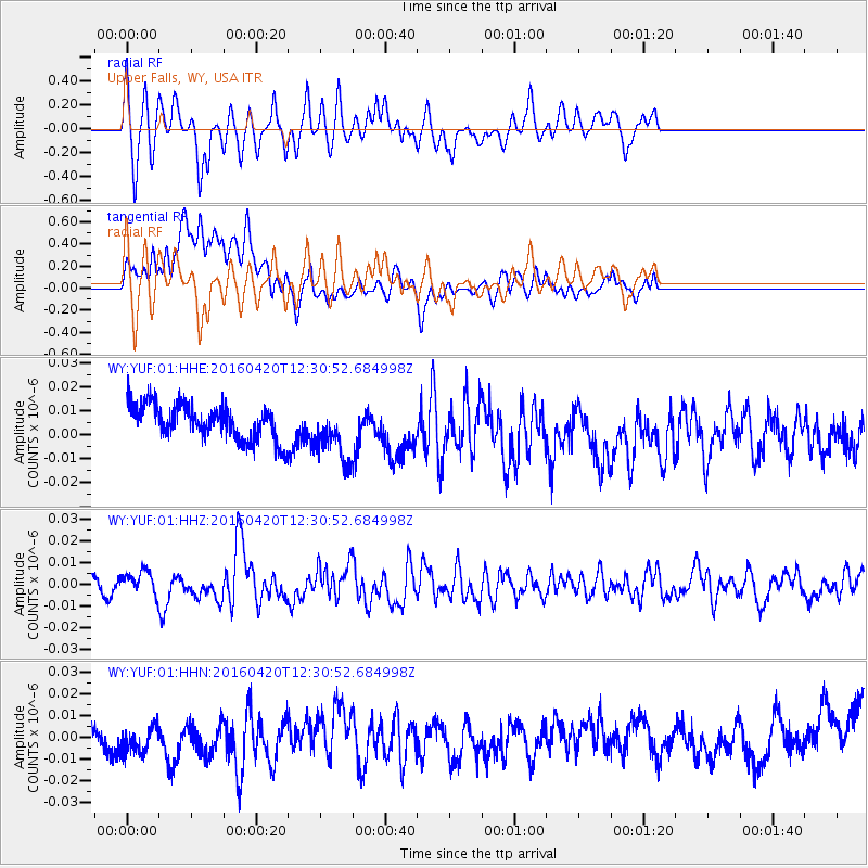
YUF Upper Falls, WY, USA - Earthquake Result Viewer
*The percent match for this event was below the threshold and hence no stack was calculated.
| Earthquake location: |
Near East Coast Of Honshu, Japan |
| Earthquake latitude/longitude: |
37.8/141.6 |
| Earthquake time(UTC): |
2016/04/20 (111) 12:19:45 GMT |
| Earthquake Depth: |
41 km |
| Earthquake Magnitude: |
5.8 MB |
| Earthquake Catalog/Contributor: |
NEIC PDE/NEIC ALERT |
|
| Network: |
WY Yellowstone Wyoming Seismic Network |
| Station: |
YUF Upper Falls, WY, USA |
| Lat/Lon: |
44.71 N/110.51 W |
| Elevation: |
2394 m |
|
| Distance: |
75.3 deg |
| Az: |
44.556 deg |
| Baz: |
308.797 deg |
| Ray Param: |
$rayparam |
*The percent match for this event was below the threshold and hence was not used in the summary stack. |
|
| Radial Match: |
62.26692 % |
| Radial Bump: |
400 |
| Transverse Match: |
25.732388 % |
| Transverse Bump: |
400 |
| SOD ConfigId: |
1475611 |
| Insert Time: |
2016-05-04 12:28:57.287 +0000 |
| GWidth: |
2.5 |
| Max Bumps: |
400 |
| Tol: |
0.001 |
|
Signal To Noise
| Channel | StoN | STA | LTA |
| WY:YUF:01:HHZ:20160420T12:30:52.684998Z | 1.6487404 | 5.3459286E-9 | 3.242432E-9 |
| WY:YUF:01:HHN:20160420T12:30:52.684998Z | 1.2084415 | 1.228814E-8 | 1.0168585E-8 |
| WY:YUF:01:HHE:20160420T12:30:52.684998Z | 1.6616877 | 1.2030299E-8 | 7.239808E-9 |
| Arrivals |
| Ps | |
| PpPs | |
| PsPs/PpSs | |


