You are here: Home > Network List > TA - USArray Transportable Network (new EarthScope stations) Stations List
> Station Y12C Blythe, CA, USA > Earthquake Result Viewer
Y12C Blythe, CA, USA - Earthquake Result Viewer

| Earthquake location: |
Jujuy Province, Argentina |
| Earthquake latitude/longitude: |
-22.2/-65.8 |
| Earthquake time(UTC): |
2007/07/21 (202) 15:34:52 GMT |
| Earthquake Depth: |
290 km |
| Earthquake Magnitude: |
5.8 MB, 6.4 MW, 6.3 MW |
| Earthquake Catalog/Contributor: |
WHDF/NEIC |
|
| Network: |
TA USArray Transportable Network (new EarthScope stations) |
| Station: |
Y12C Blythe, CA, USA |
| Lat/Lon: |
33.75 N/114.52 W |
| Elevation: |
196 m |
|
| Distance: |
72.4 deg |
| Az: |
318.923 deg |
| Baz: |
133.02 deg |
| Ray Param: |
0.05284908 |
| Estimated Moho Depth: |
15.25 km |
| Estimated Crust Vp/Vs: |
1.61 |
| Assumed Crust Vp: |
6.155 km/s |
| Estimated Crust Vs: |
3.835 km/s |
| Estimated Crust Poisson's Ratio: |
0.18 |
|
| Radial Match: |
93.02828 % |
| Radial Bump: |
400 |
| Transverse Match: |
78.68287 % |
| Transverse Bump: |
400 |
| SOD ConfigId: |
2564 |
| Insert Time: |
2010-03-06 09:09:45.955 +0000 |
| GWidth: |
2.5 |
| Max Bumps: |
400 |
| Tol: |
0.001 |
|
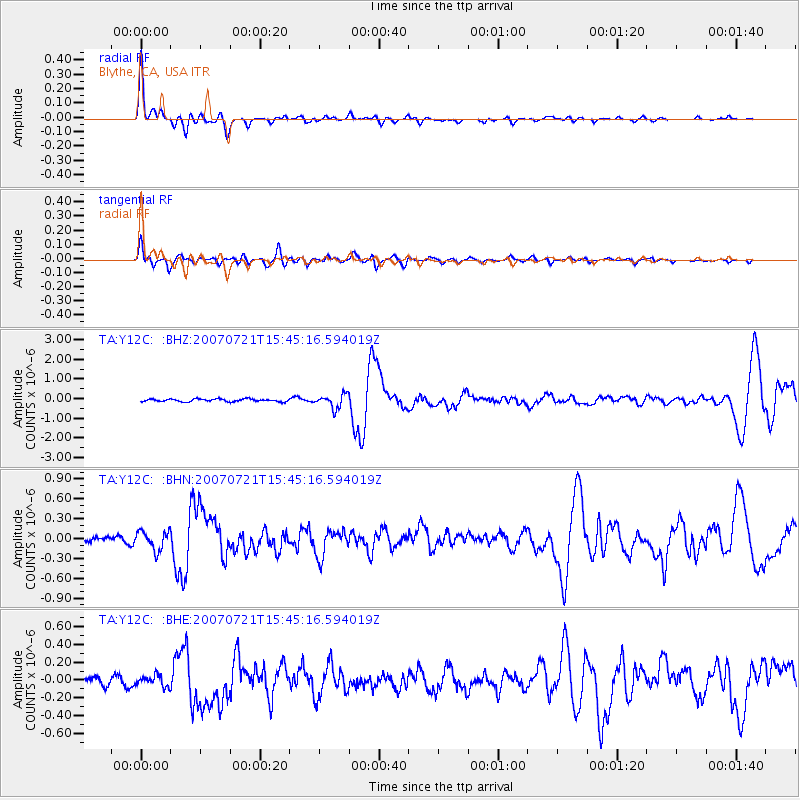
Signal To Noise
| Channel | StoN | STA | LTA |
| TA:Y12C: :BHN:20070721T15:45:16.594019Z | 2.4426413 | 1.4347386E-7 | 5.8737182E-8 |
| TA:Y12C: :BHE:20070721T15:45:16.594019Z | 0.93824726 | 6.150456E-8 | 6.555261E-8 |
| TA:Y12C: :BHZ:20070721T15:45:16.594019Z | 5.0867987 | 3.4528517E-7 | 6.787868E-8 |
| Arrivals |
| Ps | 1.6 SECOND |
| PpPs | 6.2 SECOND |
| PsPs/PpSs | 7.8 SECOND |


