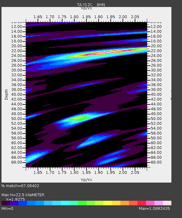
Y12C Blythe, CA, USA - Earthquake Result Viewer

Earthquake location: Kermadec Islands, New Zealand
Earthquake latitude/longitude: -30.7/-178.2
Earthquake time(UTC): 2007/05/17 (137) 19:29:10 GMT
Earthquake Depth: 41 km
Earthquake Magnitude: 5.5 MB, 5.6 MS, 6.0 MW, 5.9 MW
Earthquake Catalog/Contributor: WHDF/NEIC
Network: TA USArray Transportable Network (new EarthScope stations)
Station: Y12C Blythe, CA, USA
Lat/Lon: 33.75 N/114.52 W
Elevation: 196 m
Distance: 87.8 deg
Az: 48.36 deg
Baz: 230.618 deg
Ray Param: 0.04297401
Estimated Moho Depth: 22.5 km
Estimated Crust Vp/Vs: 1.93
Assumed Crust Vp: 6.155 km/s
Estimated Crust Vs: 3.193 km/s
Estimated Crust Poisson's Ratio: 0.32
Radial Match: 87.09402 %
Radial Bump: 400
Transverse Match: 65.497894 %
Transverse Bump: 400
SOD ConfigId: 2564
Insert Time: 2010-03-06 09:10:04.756 +0000
GWidth: 2.5
Max Bumps: 400
Tol: 0.001

Signal To Noise

ChannelStoNSTALTA
TA:Y12C: :BHN:20070517T19:41:24.070007Z1.85680461.3060503E-77.03386E-8
TA:Y12C: :BHE:20070517T19:41:24.070007Z1.81937621.2942661E-77.1137904E-8
TA:Y12C: :BHZ:20070517T19:41:24.070007Z6.36454873.5127013E-75.519168E-8
Arrivals
Ps3.5 SECOND
PpPs11 SECOND
PsPs/PpSs14 SECOND