You are here: Home > Network List > TA - USArray Transportable Network (new EarthScope stations) Stations List
> Station Y12C Blythe, CA, USA > Earthquake Result Viewer
Y12C Blythe, CA, USA - Earthquake Result Viewer
| Earthquake location: |
Vanuatu Islands |
| Earthquake latitude/longitude: |
-20.6/169.4 |
| Earthquake time(UTC): |
2007/03/25 (084) 00:40:01 GMT |
| Earthquake Depth: |
34 km |
| Earthquake Magnitude: |
6.5 MB, 7.0 MS, 7.1 MW, 7.1 MW |
| Earthquake Catalog/Contributor: |
WHDF/NEIC |
|
| Network: |
TA USArray Transportable Network (new EarthScope stations) |
| Station: |
Y12C Blythe, CA, USA |
| Lat/Lon: |
33.75 N/114.52 W |
| Elevation: |
196 m |
|
| Distance: |
90.4 deg |
| Az: |
53.986 deg |
| Baz: |
245.422 deg |
| Ray Param: |
0.041674547 |
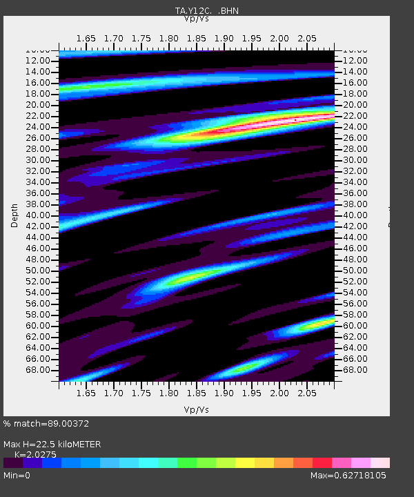
| Estimated Moho Depth: |
22.5 km |
| Estimated Crust Vp/Vs: |
2.03 |
| Assumed Crust Vp: |
6.155 km/s |
| Estimated Crust Vs: |
3.036 km/s |
| Estimated Crust Poisson's Ratio: |
0.34 |
|
| Radial Match: |
89.00372 % |
| Radial Bump: |
400 |
| Transverse Match: |
70.44779 % |
| Transverse Bump: |
400 |
| SOD ConfigId: |
2564 |
| Insert Time: |
2010-03-06 09:10:10.559 +0000 |
| GWidth: |
2.5 |
| Max Bumps: |
400 |
| Tol: |
0.001 |
|

Signal To Noise
| Channel | StoN | STA | LTA |
| TA:Y12C: :BHN:20070325T00:52:28.044021Z | 6.1384296 | 5.1910786E-7 | 8.456688E-8 |
| TA:Y12C: :BHE:20070325T00:52:28.044021Z | 5.118408 | 1.2712565E-6 | 2.4836947E-7 |
| TA:Y12C: :BHZ:20070325T00:52:28.044021Z | 17.07114 | 4.0102245E-6 | 2.3491252E-7 |
| Arrivals |
| Ps | 3.8 SECOND |
| PpPs | 11 SECOND |
| PsPs/PpSs | 15 SECOND |


