You are here: Home > Network List > TA - USArray Transportable Network (new EarthScope stations) Stations List
> Station Y12C Blythe, CA, USA > Earthquake Result Viewer
Y12C Blythe, CA, USA - Earthquake Result Viewer

| Earthquake location: |
South Of Panama |
| Earthquake latitude/longitude: |
4.6/-78.5 |
| Earthquake time(UTC): |
2007/03/18 (077) 02:11:05 GMT |
| Earthquake Depth: |
8.0 km |
| Earthquake Magnitude: |
6.4 MB, 5.7 MS, 6.2 MW, 6.1 MW |
| Earthquake Catalog/Contributor: |
WHDF/NEIC |
|
| Network: |
TA USArray Transportable Network (new EarthScope stations) |
| Station: |
Y12C Blythe, CA, USA |
| Lat/Lon: |
33.75 N/114.52 W |
| Elevation: |
196 m |
|
| Distance: |
44.3 deg |
| Az: |
315.45 deg |
| Baz: |
122.93 deg |
| Ray Param: |
0.0720048 |
| Estimated Moho Depth: |
26.5 km |
| Estimated Crust Vp/Vs: |
1.76 |
| Assumed Crust Vp: |
6.155 km/s |
| Estimated Crust Vs: |
3.487 km/s |
| Estimated Crust Poisson's Ratio: |
0.26 |
|
| Radial Match: |
93.13071 % |
| Radial Bump: |
364 |
| Transverse Match: |
72.652435 % |
| Transverse Bump: |
400 |
| SOD ConfigId: |
2564 |
| Insert Time: |
2010-03-06 09:10:12.263 +0000 |
| GWidth: |
2.5 |
| Max Bumps: |
400 |
| Tol: |
0.001 |
|
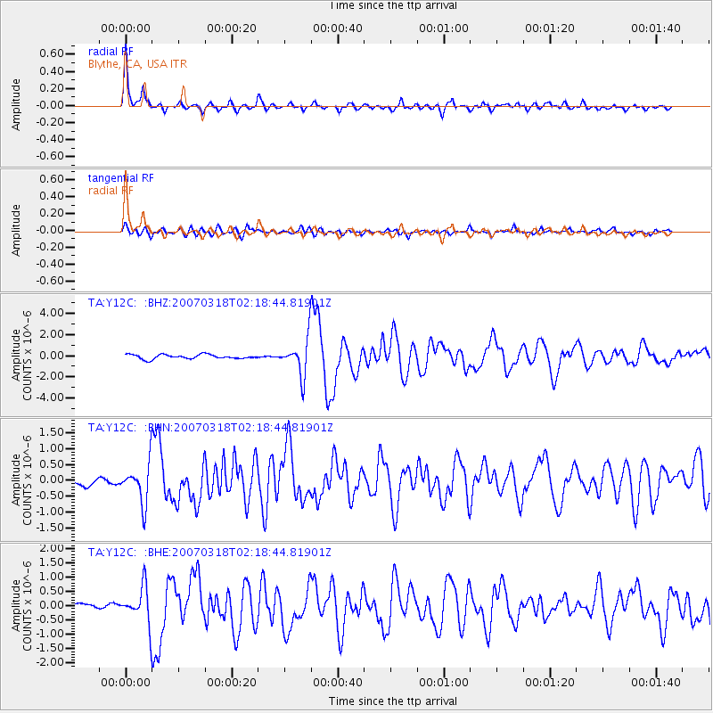
Signal To Noise
| Channel | StoN | STA | LTA |
| TA:Y12C: :BHN:20070318T02:18:44.81901Z | 4.3424554 | 6.291121E-7 | 1.4487473E-7 |
| TA:Y12C: :BHE:20070318T02:18:44.81901Z | 2.825045 | 6.41742E-7 | 2.2716169E-7 |
| TA:Y12C: :BHZ:20070318T02:18:44.81901Z | 8.677163 | 1.7797691E-6 | 2.0510957E-7 |
| Arrivals |
| Ps | 3.5 SECOND |
| PpPs | 11 SECOND |
| PsPs/PpSs | 15 SECOND |


