You are here: Home > Network List > OX - North-East Italy Seismic Network Stations List
> Station CGRP Cima Grappa > Earthquake Result Viewer
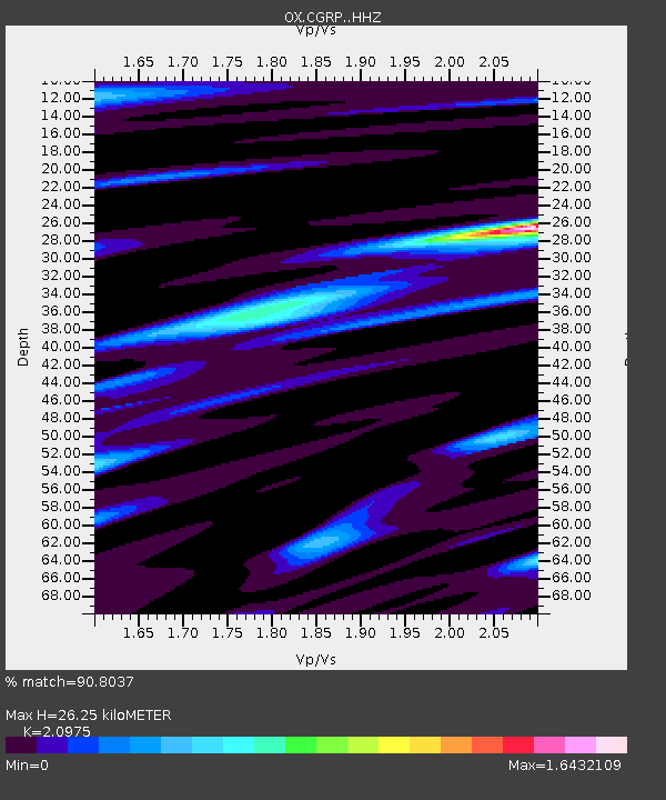
CGRP Cima Grappa - Earthquake Result Viewer
| Earthquake location: |
Oaxaca, Mexico |
| Earthquake latitude/longitude: |
16.4/-97.9 |
| Earthquake time(UTC): |
2018/02/16 (047) 23:39:44 GMT |
| Earthquake Depth: |
43 km |
| Earthquake Magnitude: |
7.5 Mi |
| Earthquake Catalog/Contributor: |
NEIC PDE/at |
|
| Network: |
OX North-East Italy Seismic Network |
| Station: |
CGRP Cima Grappa |
| Lat/Lon: |
45.88 N/11.80 E |
| Elevation: |
1757 m |
|
| Distance: |
91.4 deg |
| Az: |
41.137 deg |
| Baz: |
295.323 deg |
| Ray Param: |
0.041594945 |
| Estimated Moho Depth: |
26.25 km |
| Estimated Crust Vp/Vs: |
2.10 |
| Assumed Crust Vp: |
6.155 km/s |
| Estimated Crust Vs: |
2.934 km/s |
| Estimated Crust Poisson's Ratio: |
0.35 |
|
| Radial Match: |
90.8037 % |
| Radial Bump: |
400 |
| Transverse Match: |
77.85897 % |
| Transverse Bump: |
400 |
| SOD ConfigId: |
13570011 |
| Insert Time: |
2019-04-29 20:10:39.023 +0000 |
| GWidth: |
2.5 |
| Max Bumps: |
400 |
| Tol: |
0.001 |
|

Signal To Noise
| Channel | StoN | STA | LTA |
| OX:CGRP: :HHZ:20180216T23:52:12.348022Z | 13.986053 | 3.9826637E-6 | 2.8475964E-7 |
| OX:CGRP: :HHN:20180216T23:52:12.348022Z | 2.696521 | 5.26947E-7 | 1.9541734E-7 |
| OX:CGRP: :HHE:20180216T23:52:12.348022Z | 4.6994963 | 1.4165505E-6 | 3.0142604E-7 |
| Arrivals |
| Ps | 4.8 SECOND |
| PpPs | 13 SECOND |
| PsPs/PpSs | 18 SECOND |


