You are here: Home > Network List > GS - US Geological Survey Networks Stations List
> Station KAN06 West of Argonia, Argonia, KS, USA > Earthquake Result Viewer
KAN06 West of Argonia, Argonia, KS, USA - Earthquake Result Viewer
| Earthquake location: |
Near Coast Of Ecuador |
| Earthquake latitude/longitude: |
-0.3/-80.5 |
| Earthquake time(UTC): |
2016/04/22 (113) 03:03:42 GMT |
| Earthquake Depth: |
10 km |
| Earthquake Magnitude: |
6.0 MO |
| Earthquake Catalog/Contributor: |
NEIC PDE/NEIC ALERT |
|
| Network: |
GS US Geological Survey Networks |
| Station: |
KAN06 West of Argonia, Argonia, KS, USA |
| Lat/Lon: |
37.25 N/97.86 W |
| Elevation: |
393 m |
|
| Distance: |
40.7 deg |
| Az: |
338.631 deg |
| Baz: |
152.831 deg |
| Ray Param: |
0.07425993 |
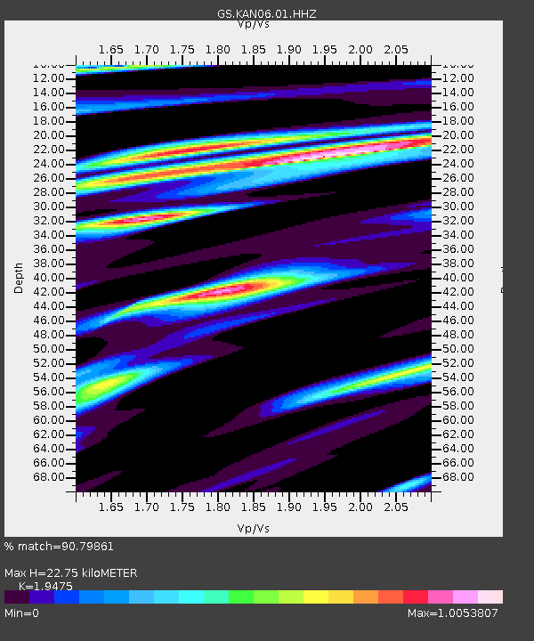
| Estimated Moho Depth: |
22.75 km |
| Estimated Crust Vp/Vs: |
1.95 |
| Assumed Crust Vp: |
6.483 km/s |
| Estimated Crust Vs: |
3.329 km/s |
| Estimated Crust Poisson's Ratio: |
0.32 |
|
| Radial Match: |
90.79861 % |
| Radial Bump: |
318 |
| Transverse Match: |
64.24125 % |
| Transverse Bump: |
400 |
| SOD ConfigId: |
1475611 |
| Insert Time: |
2016-05-06 03:06:19.744 +0000 |
| GWidth: |
2.5 |
| Max Bumps: |
400 |
| Tol: |
0.001 |
|

Signal To Noise
| Channel | StoN | STA | LTA |
| GS:KAN06:01:HHZ:20160422T03:10:51.569Z | 4.4399076 | 6.647584E-7 | 1.4972348E-7 |
| GS:KAN06:01:HHN:20160422T03:10:51.569Z | 2.4823308 | 3.1884545E-7 | 1.28446E-7 |
| GS:KAN06:01:HHE:20160422T03:10:51.569Z | 3.1705499 | 3.7177355E-7 | 1.1725838E-7 |
| Arrivals |
| Ps | 3.5 SECOND |
| PpPs | 9.7 SECOND |
| PsPs/PpSs | 13 SECOND |


