You are here: Home > Network List > TA - USArray Transportable Network (new EarthScope stations) Stations List
> Station D25K Kavik River, AK, USA > Earthquake Result Viewer
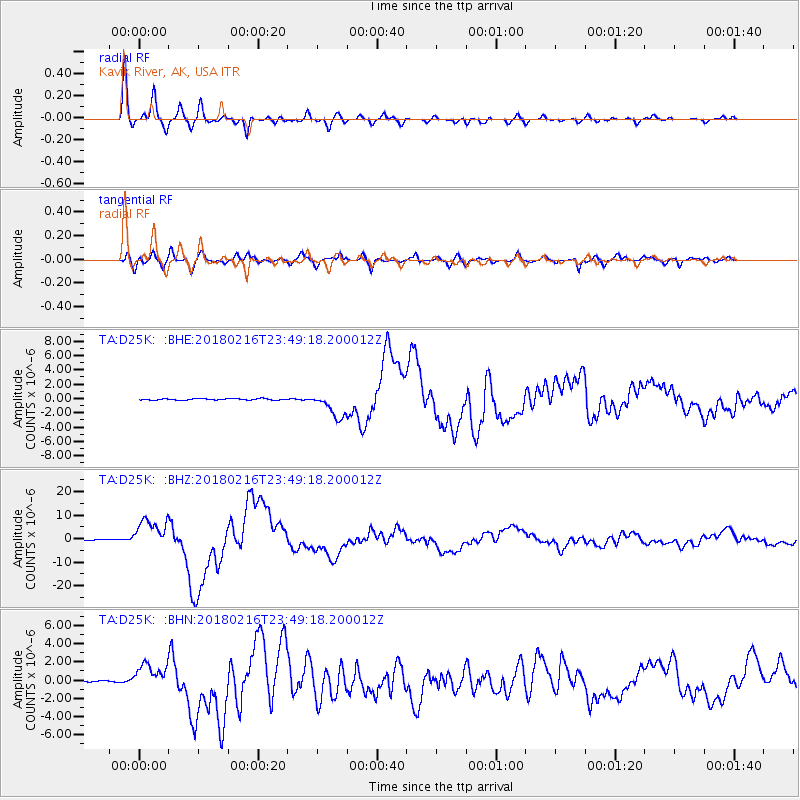
D25K Kavik River, AK, USA - Earthquake Result Viewer
*The percent match for this event was below the threshold and hence no stack was calculated.
| Earthquake location: |
Oaxaca, Mexico |
| Earthquake latitude/longitude: |
16.4/-97.9 |
| Earthquake time(UTC): |
2018/02/16 (047) 23:39:44 GMT |
| Earthquake Depth: |
43 km |
| Earthquake Magnitude: |
7.5 Mi |
| Earthquake Catalog/Contributor: |
NEIC PDE/at |
|
| Network: |
TA USArray Transportable Network (new EarthScope stations) |
| Station: |
D25K Kavik River, AK, USA |
| Lat/Lon: |
69.32 N/146.38 W |
| Elevation: |
770 m |
|
| Distance: |
60.8 deg |
| Az: |
342.258 deg |
| Baz: |
124.569 deg |
| Ray Param: |
$rayparam |
*The percent match for this event was below the threshold and hence was not used in the summary stack. |
|
| Radial Match: |
97.34995 % |
| Radial Bump: |
400 |
| Transverse Match: |
88.37966 % |
| Transverse Bump: |
400 |
| SOD ConfigId: |
13570011 |
| Insert Time: |
2019-04-29 20:11:35.575 +0000 |
| GWidth: |
2.5 |
| Max Bumps: |
400 |
| Tol: |
0.001 |
|
Signal To Noise
| Channel | StoN | STA | LTA |
| TA:D25K: :BHZ:20180216T23:49:18.200012Z | 75.48664 | 6.5409704E-6 | 8.66507E-8 |
| TA:D25K: :BHN:20180216T23:49:18.200012Z | 12.190184 | 1.4586957E-6 | 1.1966151E-7 |
| TA:D25K: :BHE:20180216T23:49:18.200012Z | 28.428488 | 2.538732E-6 | 8.930239E-8 |
| Arrivals |
| Ps | |
| PpPs | |
| PsPs/PpSs | |


