You are here: Home > Network List > TA - USArray Transportable Network (new EarthScope stations) Stations List
> Station F21K Alatna River, AK, USA > Earthquake Result Viewer
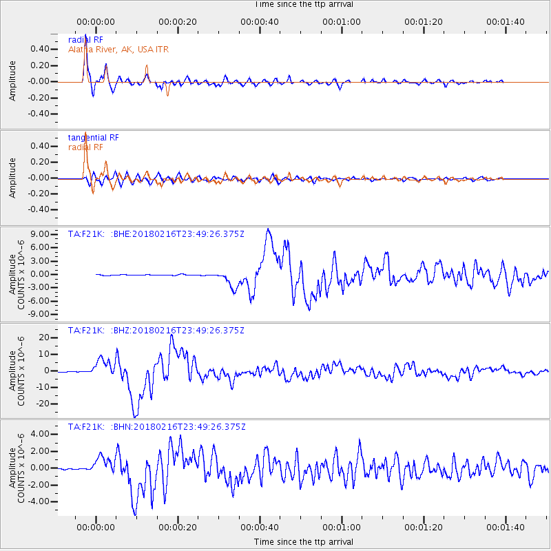
F21K Alatna River, AK, USA - Earthquake Result Viewer
*The percent match for this event was below the threshold and hence no stack was calculated.
| Earthquake location: |
Oaxaca, Mexico |
| Earthquake latitude/longitude: |
16.4/-97.9 |
| Earthquake time(UTC): |
2018/02/16 (047) 23:39:44 GMT |
| Earthquake Depth: |
43 km |
| Earthquake Magnitude: |
7.5 Mi |
| Earthquake Catalog/Contributor: |
NEIC PDE/at |
|
| Network: |
TA USArray Transportable Network (new EarthScope stations) |
| Station: |
F21K Alatna River, AK, USA |
| Lat/Lon: |
67.22 N/153.48 W |
| Elevation: |
597 m |
|
| Distance: |
62.0 deg |
| Az: |
338.663 deg |
| Baz: |
116.247 deg |
| Ray Param: |
$rayparam |
*The percent match for this event was below the threshold and hence was not used in the summary stack. |
|
| Radial Match: |
98.2239 % |
| Radial Bump: |
400 |
| Transverse Match: |
92.613304 % |
| Transverse Bump: |
400 |
| SOD ConfigId: |
13570011 |
| Insert Time: |
2019-04-29 20:11:45.077 +0000 |
| GWidth: |
2.5 |
| Max Bumps: |
400 |
| Tol: |
0.001 |
|
Signal To Noise
| Channel | StoN | STA | LTA |
| TA:F21K: :BHZ:20180216T23:49:26.375Z | 50.629616 | 6.0070643E-6 | 1.1864724E-7 |
| TA:F21K: :BHN:20180216T23:49:26.375Z | 10.440629 | 1.1333454E-6 | 1.0855145E-7 |
| TA:F21K: :BHE:20180216T23:49:26.375Z | 28.476093 | 2.4412748E-6 | 8.573068E-8 |
| Arrivals |
| Ps | |
| PpPs | |
| PsPs/PpSs | |


