You are here: Home > Network List > CI - Caltech Regional Seismic Network Stations List
> Station IRM Iron Mountain Pumping Station, Eagle Mtn., CA, USA > Earthquake Result Viewer
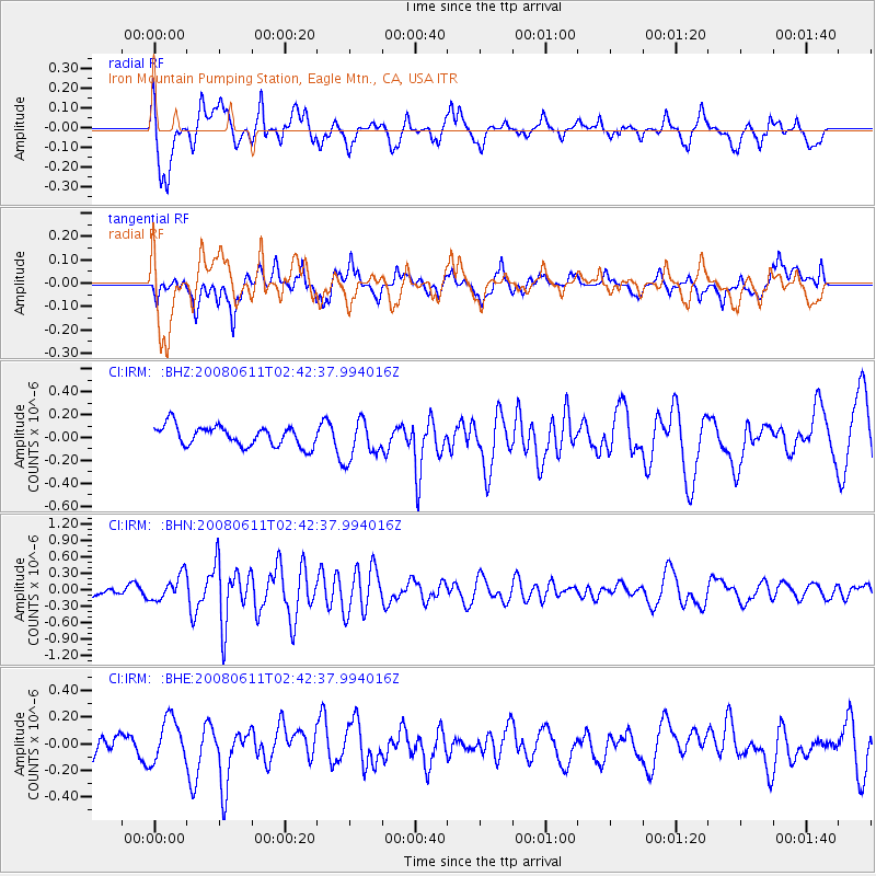
IRM Iron Mountain Pumping Station, Eagle Mtn., CA, USA - Earthquake Result Viewer
*The percent match for this event was below the threshold and hence no stack was calculated.
| Earthquake location: |
South Of Kermadec Islands |
| Earthquake latitude/longitude: |
-33.4/179.9 |
| Earthquake time(UTC): |
2008/06/11 (163) 02:30:08 GMT |
| Earthquake Depth: |
22 km |
| Earthquake Magnitude: |
5.6 MB, 5.1 MS, 5.7 MW, 5.5 MW |
| Earthquake Catalog/Contributor: |
WHDF/NEIC |
|
| Network: |
CI Caltech Regional Seismic Network |
| Station: |
IRM Iron Mountain Pumping Station, Eagle Mtn., CA, USA |
| Lat/Lon: |
34.16 N/115.15 W |
| Elevation: |
567 m |
|
| Distance: |
90.7 deg |
| Az: |
48.7 deg |
| Baz: |
229.277 deg |
| Ray Param: |
$rayparam |
*The percent match for this event was below the threshold and hence was not used in the summary stack. |
|
| Radial Match: |
72.910034 % |
| Radial Bump: |
400 |
| Transverse Match: |
57.762882 % |
| Transverse Bump: |
400 |
| SOD ConfigId: |
2504 |
| Insert Time: |
2010-02-26 01:49:20.205 +0000 |
| GWidth: |
2.5 |
| Max Bumps: |
400 |
| Tol: |
0.001 |
|
Signal To Noise
| Channel | StoN | STA | LTA |
| CI:IRM: :BHN:20080611T02:42:37.994016Z | 2.111041 | 2.2844151E-7 | 1.0821273E-7 |
| CI:IRM: :BHE:20080611T02:42:37.994016Z | 1.6117549 | 1.6306859E-7 | 1.0117456E-7 |
| CI:IRM: :BHZ:20080611T02:42:37.994016Z | 1.9485294 | 1.7087262E-7 | 8.7693124E-8 |
| Arrivals |
| Ps | |
| PpPs | |
| PsPs/PpSs | |


