You are here: Home > Network List > TA - USArray Transportable Network (new EarthScope stations) Stations List
> Station G21K Allakaket, AK, USA > Earthquake Result Viewer
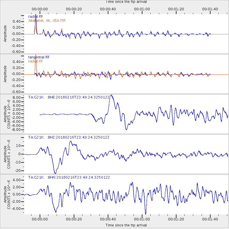
G21K Allakaket, AK, USA - Earthquake Result Viewer
*The percent match for this event was below the threshold and hence no stack was calculated.
| Earthquake location: |
Oaxaca, Mexico |
| Earthquake latitude/longitude: |
16.4/-97.9 |
| Earthquake time(UTC): |
2018/02/16 (047) 23:39:44 GMT |
| Earthquake Depth: |
43 km |
| Earthquake Magnitude: |
7.5 Mi |
| Earthquake Catalog/Contributor: |
NEIC PDE/at |
|
| Network: |
TA USArray Transportable Network (new EarthScope stations) |
| Station: |
G21K Allakaket, AK, USA |
| Lat/Lon: |
66.52 N/153.51 W |
| Elevation: |
446 m |
|
| Distance: |
61.7 deg |
| Az: |
337.936 deg |
| Baz: |
115.883 deg |
| Ray Param: |
$rayparam |
*The percent match for this event was below the threshold and hence was not used in the summary stack. |
|
| Radial Match: |
96.120995 % |
| Radial Bump: |
400 |
| Transverse Match: |
86.56767 % |
| Transverse Bump: |
400 |
| SOD ConfigId: |
13570011 |
| Insert Time: |
2019-04-29 20:11:51.900 +0000 |
| GWidth: |
2.5 |
| Max Bumps: |
400 |
| Tol: |
0.001 |
|
Signal To Noise
| Channel | StoN | STA | LTA |
| TA:G21K: :BHZ:20180216T23:49:24.325012Z | 55.032936 | 6.0467814E-6 | 1.0987568E-7 |
| TA:G21K: :BHN:20180216T23:49:24.325012Z | 10.548485 | 1.3927134E-6 | 1.3202973E-7 |
| TA:G21K: :BHE:20180216T23:49:24.325012Z | 21.999645 | 2.795423E-6 | 1.2706673E-7 |
| Arrivals |
| Ps | |
| PpPs | |
| PsPs/PpSs | |


