You are here: Home > Network List > TA - USArray Transportable Network (new EarthScope stations) Stations List
> Station Y12C Blythe, CA, USA > Earthquake Result Viewer
Y12C Blythe, CA, USA - Earthquake Result Viewer
| Earthquake location: |
Samoa Islands Region |
| Earthquake latitude/longitude: |
-16.6/-172.0 |
| Earthquake time(UTC): |
2006/09/28 (271) 06:22:09 GMT |
| Earthquake Depth: |
28 km |
| Earthquake Magnitude: |
6.5 MB, 6.6 MS, 6.9 MW, 6.7 MW |
| Earthquake Catalog/Contributor: |
WHDF/NEIC |
|
| Network: |
TA USArray Transportable Network (new EarthScope stations) |
| Station: |
Y12C Blythe, CA, USA |
| Lat/Lon: |
33.75 N/114.52 W |
| Elevation: |
196 m |
|
| Distance: |
74.2 deg |
| Az: |
46.916 deg |
| Baz: |
237.197 deg |
| Ray Param: |
0.052453868 |
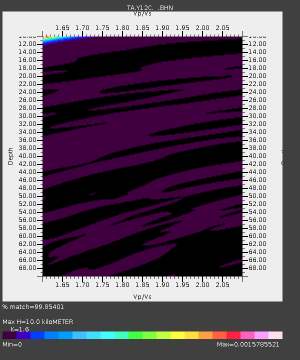
| Estimated Moho Depth: |
10.0 km |
| Estimated Crust Vp/Vs: |
1.60 |
| Assumed Crust Vp: |
6.155 km/s |
| Estimated Crust Vs: |
3.847 km/s |
| Estimated Crust Poisson's Ratio: |
0.18 |
|
| Radial Match: |
99.85401 % |
| Radial Bump: |
15 |
| Transverse Match: |
99.83359 % |
| Transverse Bump: |
20 |
| SOD ConfigId: |
2564 |
| Insert Time: |
2010-03-06 09:11:08.776 +0000 |
| GWidth: |
2.5 |
| Max Bumps: |
400 |
| Tol: |
0.001 |
|
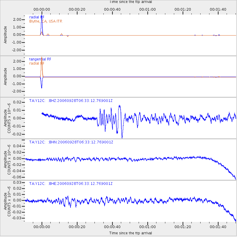
Signal To Noise
| Channel | StoN | STA | LTA |
| TA:Y12C: :BHN:20060928T06:33:12.769001Z | 1.2884543 | 5.8543663E-9 | 4.5437125E-9 |
| TA:Y12C: :BHE:20060928T06:33:12.769001Z | 0.760249 | 2.1787063E-9 | 2.8657798E-9 |
| TA:Y12C: :BHZ:20060928T06:33:12.769001Z | 2.439229 | 5.8135097E-9 | 2.383339E-9 |
| Arrivals |
| Ps | 1.0 SECOND |
| PpPs | 4.1 SECOND |
| PsPs/PpSs | 5.1 SECOND |


