You are here: Home > Network List > TA - USArray Transportable Network (new EarthScope stations) Stations List
> Station R31K City Hall, Gustavus, AK, USA > Earthquake Result Viewer
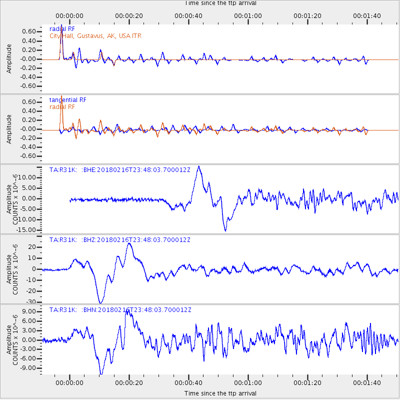
R31K City Hall, Gustavus, AK, USA - Earthquake Result Viewer
*The percent match for this event was below the threshold and hence no stack was calculated.
| Earthquake location: |
Oaxaca, Mexico |
| Earthquake latitude/longitude: |
16.4/-97.9 |
| Earthquake time(UTC): |
2018/02/16 (047) 23:39:44 GMT |
| Earthquake Depth: |
43 km |
| Earthquake Magnitude: |
7.5 Mi |
| Earthquake Catalog/Contributor: |
NEIC PDE/at |
|
| Network: |
TA USArray Transportable Network (new EarthScope stations) |
| Station: |
R31K City Hall, Gustavus, AK, USA |
| Lat/Lon: |
58.41 N/135.74 W |
| Elevation: |
15 m |
|
| Distance: |
50.4 deg |
| Az: |
335.221 deg |
| Baz: |
130.156 deg |
| Ray Param: |
$rayparam |
*The percent match for this event was below the threshold and hence was not used in the summary stack. |
|
| Radial Match: |
95.09933 % |
| Radial Bump: |
400 |
| Transverse Match: |
77.57594 % |
| Transverse Bump: |
400 |
| SOD ConfigId: |
13570011 |
| Insert Time: |
2019-04-29 20:13:10.953 +0000 |
| GWidth: |
2.5 |
| Max Bumps: |
400 |
| Tol: |
0.001 |
|
Signal To Noise
| Channel | StoN | STA | LTA |
| TA:R31K: :BHZ:20180216T23:48:03.700012Z | 19.246664 | 6.1006E-6 | 3.169692E-7 |
| TA:R31K: :BHN:20180216T23:48:03.700012Z | 7.377458 | 2.2543998E-6 | 3.0557948E-7 |
| TA:R31K: :BHE:20180216T23:48:03.700012Z | 8.38104 | 2.9723135E-6 | 3.5464734E-7 |
| Arrivals |
| Ps | |
| PpPs | |
| PsPs/PpSs | |


