You are here: Home > Network List > GS - US Geological Survey Networks Stations List
> Station OK035 E0210 Rd and N2420 Rd, Alva, Oklahoma, USA > Earthquake Result Viewer
OK035 E0210 Rd and N2420 Rd, Alva, Oklahoma, USA - Earthquake Result Viewer
| Earthquake location: |
Near Coast Of Ecuador |
| Earthquake latitude/longitude: |
-0.3/-80.5 |
| Earthquake time(UTC): |
2016/04/22 (113) 03:03:42 GMT |
| Earthquake Depth: |
10 km |
| Earthquake Magnitude: |
6.0 MO |
| Earthquake Catalog/Contributor: |
NEIC PDE/NEIC ALERT |
|
| Network: |
GS US Geological Survey Networks |
| Station: |
OK035 E0210 Rd and N2420 Rd, Alva, Oklahoma, USA |
| Lat/Lon: |
36.71 N/98.71 W |
| Elevation: |
485 m |
|
| Distance: |
40.5 deg |
| Az: |
337.318 deg |
| Baz: |
151.324 deg |
| Ray Param: |
0.07435263 |
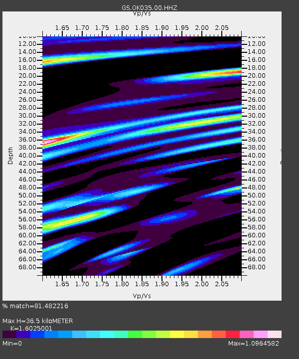
| Estimated Moho Depth: |
36.5 km |
| Estimated Crust Vp/Vs: |
1.60 |
| Assumed Crust Vp: |
6.426 km/s |
| Estimated Crust Vs: |
4.01 km/s |
| Estimated Crust Poisson's Ratio: |
0.18 |
|
| Radial Match: |
81.482216 % |
| Radial Bump: |
394 |
| Transverse Match: |
67.29123 % |
| Transverse Bump: |
400 |
| SOD ConfigId: |
1475611 |
| Insert Time: |
2016-05-06 03:07:20.376 +0000 |
| GWidth: |
2.5 |
| Max Bumps: |
400 |
| Tol: |
0.001 |
|

Signal To Noise
| Channel | StoN | STA | LTA |
| GS:OK035:00:HHZ:20160422T03:10:50.278992Z | 5.8411126 | 5.9898525E-7 | 1.0254643E-7 |
| GS:OK035:00:HH1:20160422T03:10:50.278992Z | 1.2108307 | 2.4061356E-7 | 1.9871776E-7 |
| GS:OK035:00:HH2:20160422T03:10:50.278992Z | 1.1134859 | 3.3638037E-7 | 3.0209662E-7 |
| Arrivals |
| Ps | 3.7 SECOND |
| PpPs | 14 SECOND |
| PsPs/PpSs | 17 SECOND |


