You are here: Home > Network List > TA - USArray Transportable Network (new EarthScope stations) Stations List
> Station Y12C Blythe, CA, USA > Earthquake Result Viewer
Y12C Blythe, CA, USA - Earthquake Result Viewer
| Earthquake location: |
Eastern Siberia, Russia |
| Earthquake latitude/longitude: |
61.4/167.5 |
| Earthquake time(UTC): |
2006/04/21 (111) 11:14:15 GMT |
| Earthquake Depth: |
12 km |
| Earthquake Magnitude: |
5.8 MB, 5.8 MS, 6.1 MW, 6.1 MW |
| Earthquake Catalog/Contributor: |
WHDF/NEIC |
|
| Network: |
TA USArray Transportable Network (new EarthScope stations) |
| Station: |
Y12C Blythe, CA, USA |
| Lat/Lon: |
33.75 N/114.52 W |
| Elevation: |
196 m |
|
| Distance: |
55.4 deg |
| Az: |
82.03 deg |
| Baz: |
325.056 deg |
| Ray Param: |
0.06483682 |
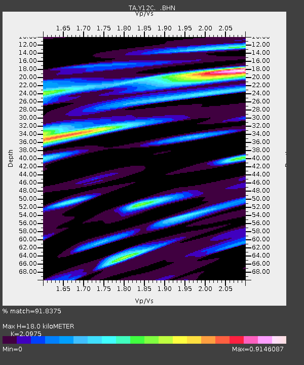
| Estimated Moho Depth: |
18.0 km |
| Estimated Crust Vp/Vs: |
2.10 |
| Assumed Crust Vp: |
6.155 km/s |
| Estimated Crust Vs: |
2.934 km/s |
| Estimated Crust Poisson's Ratio: |
0.35 |
|
| Radial Match: |
91.8375 % |
| Radial Bump: |
400 |
| Transverse Match: |
82.04644 % |
| Transverse Bump: |
400 |
| SOD ConfigId: |
2669 |
| Insert Time: |
2010-03-06 09:12:05.546 +0000 |
| GWidth: |
2.5 |
| Max Bumps: |
400 |
| Tol: |
0.001 |
|
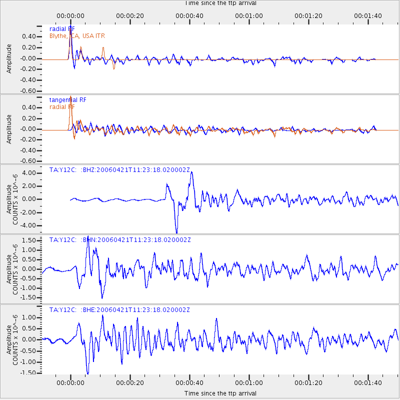
Signal To Noise
| Channel | StoN | STA | LTA |
| TA:Y12C: :BHN:20060421T11:23:18.020002Z | 4.8121223 | 3.9725316E-7 | 8.255259E-8 |
| TA:Y12C: :BHE:20060421T11:23:18.020002Z | 2.865169 | 3.29312E-7 | 1.1493633E-7 |
| TA:Y12C: :BHZ:20060421T11:23:18.020002Z | 7.018821 | 9.425847E-7 | 1.3429388E-7 |
| Arrivals |
| Ps | 3.3 SECOND |
| PpPs | 8.7 SECOND |
| PsPs/PpSs | 12 SECOND |


