You are here: Home > Network List > TA - USArray Transportable Network (new EarthScope stations) Stations List
> Station Y12C Blythe, CA, USA > Earthquake Result Viewer
Y12C Blythe, CA, USA - Earthquake Result Viewer
| Earthquake location: |
Fiji Islands Region |
| Earthquake latitude/longitude: |
-16.5/177.0 |
| Earthquake time(UTC): |
2006/04/07 (097) 08:30:45 GMT |
| Earthquake Depth: |
22 km |
| Earthquake Magnitude: |
5.9 MB, 6.4 MS, 6.4 MW, 6.4 MW |
| Earthquake Catalog/Contributor: |
WHDF/NEIC |
|
| Network: |
TA USArray Transportable Network (new EarthScope stations) |
| Station: |
Y12C Blythe, CA, USA |
| Lat/Lon: |
33.75 N/114.52 W |
| Elevation: |
196 m |
|
| Distance: |
82.2 deg |
| Az: |
51.491 deg |
| Baz: |
244.266 deg |
| Ray Param: |
0.04706188 |
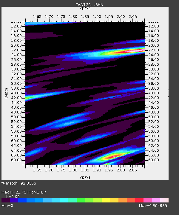
| Estimated Moho Depth: |
21.75 km |
| Estimated Crust Vp/Vs: |
2.09 |
| Assumed Crust Vp: |
6.155 km/s |
| Estimated Crust Vs: |
2.945 km/s |
| Estimated Crust Poisson's Ratio: |
0.35 |
|
| Radial Match: |
92.8356 % |
| Radial Bump: |
341 |
| Transverse Match: |
78.432846 % |
| Transverse Bump: |
400 |
| SOD ConfigId: |
2669 |
| Insert Time: |
2010-03-06 09:12:11.583 +0000 |
| GWidth: |
2.5 |
| Max Bumps: |
400 |
| Tol: |
0.001 |
|
Signal To Noise
| Channel | StoN | STA | LTA |
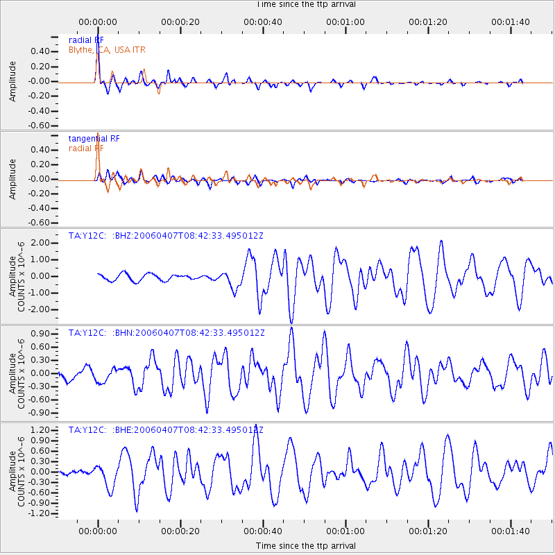
| TA:Y12C: :BHN:20060407T08:42:33.495012Z | 0.66539526 | 1.4952215E-7 | 2.2471177E-7 |
| TA:Y12C: :BHE:20060407T08:42:33.495012Z | 3.632902 | 3.4089808E-7 | 9.38363E-8 |
| TA:Y12C: :BHZ:20060407T08:42:33.495012Z | 2.6746156 | 5.1804096E-7 | 1.93688E-7 |
| Arrivals |
| Ps | 3.9 SECOND |
| PpPs | 11 SECOND |
| PsPs/PpSs | 15 SECOND |


