You are here: Home > Network List > TA - USArray Transportable Network (new EarthScope stations) Stations List
> Station Y12C Blythe, CA, USA > Earthquake Result Viewer
Y12C Blythe, CA, USA - Earthquake Result Viewer
| Earthquake location: |
Northern Mid-Atlantic Ridge |
| Earthquake latitude/longitude: |
31.1/-41.4 |
| Earthquake time(UTC): |
2006/01/20 (020) 08:53:52 GMT |
| Earthquake Depth: |
10 km |
| Earthquake Magnitude: |
5.5 MB, 5.4 MS, 5.7 MW, 5.6 MW |
| Earthquake Catalog/Contributor: |
WHDF/NEIC |
|
| Network: |
TA USArray Transportable Network (new EarthScope stations) |
| Station: |
Y12C Blythe, CA, USA |
| Lat/Lon: |
33.75 N/114.52 W |
| Elevation: |
196 m |
|
| Distance: |
60.5 deg |
| Az: |
293.713 deg |
| Baz: |
70.553 deg |
| Ray Param: |
0.06146309 |
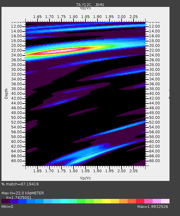
| Estimated Moho Depth: |
22.0 km |
| Estimated Crust Vp/Vs: |
1.74 |
| Assumed Crust Vp: |
6.155 km/s |
| Estimated Crust Vs: |
3.532 km/s |
| Estimated Crust Poisson's Ratio: |
0.25 |
|
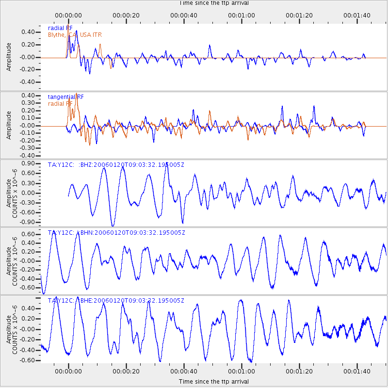
| Radial Match: |
87.19419 % |
| Radial Bump: |
400 |
| Transverse Match: |
64.945076 % |
| Transverse Bump: |
328 |
| SOD ConfigId: |
132717 |
| Insert Time: |
2010-03-06 09:12:16.928 +0000 |
| GWidth: |
2.5 |
| Max Bumps: |
400 |
| Tol: |
0.001 |
|
Signal To Noise
| Channel | StoN | STA | LTA |
| TA:Y12C: :BHN:20060120T09:03:32.195005Z | 1.3129954 | 3.8889237E-7 | 2.9618715E-7 |
| TA:Y12C: :BHE:20060120T09:03:32.195005Z | 1.6167616 | 4.2429662E-7 | 2.624361E-7 |
| TA:Y12C: :BHZ:20060120T09:03:32.195005Z | 1.2907293 | 5.744611E-7 | 4.4506712E-7 |
| Arrivals |
| Ps | 2.8 SECOND |
| PpPs | 9.4 SECOND |
| PsPs/PpSs | 12 SECOND |


