You are here: Home > Network List > TA - USArray Transportable Network (new EarthScope stations) Stations List
> Station Y12C Blythe, CA, USA > Earthquake Result Viewer
Y12C Blythe, CA, USA - Earthquake Result Viewer

| Earthquake location: |
Fiji Islands Region |
| Earthquake latitude/longitude: |
-19.9/-178.2 |
| Earthquake time(UTC): |
2006/01/02 (002) 22:13:40 GMT |
| Earthquake Depth: |
583 km |
| Earthquake Magnitude: |
6.5 MB, 7.2 MW, 7.1 MW |
| Earthquake Catalog/Contributor: |
WHDF/NEIC |
|
| Network: |
TA USArray Transportable Network (new EarthScope stations) |
| Station: |
Y12C Blythe, CA, USA |
| Lat/Lon: |
33.75 N/114.52 W |
| Elevation: |
196 m |
|
| Distance: |
80.8 deg |
| Az: |
49.153 deg |
| Baz: |
238.673 deg |
| Ray Param: |
0.04627997 |
| Estimated Moho Depth: |
64.75 km |
| Estimated Crust Vp/Vs: |
2.00 |
| Assumed Crust Vp: |
6.155 km/s |
| Estimated Crust Vs: |
3.085 km/s |
| Estimated Crust Poisson's Ratio: |
0.33 |
|
| Radial Match: |
90.63833 % |
| Radial Bump: |
322 |
| Transverse Match: |
86.97367 % |
| Transverse Bump: |
400 |
| SOD ConfigId: |
2422 |
| Insert Time: |
2010-03-06 09:12:19.071 +0000 |
| GWidth: |
2.5 |
| Max Bumps: |
400 |
| Tol: |
0.001 |
|
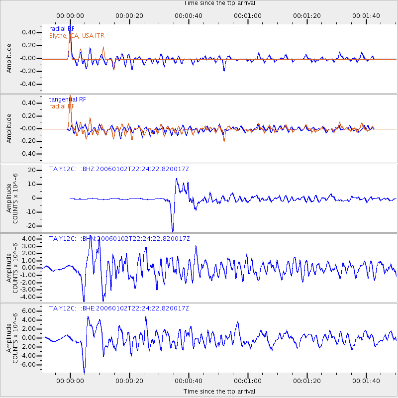
Signal To Noise
| Channel | StoN | STA | LTA |
| TA:Y12C: :BHN:20060102T22:24:22.820017Z | 9.976305 | 1.5838477E-6 | 1.5876097E-7 |
| TA:Y12C: :BHE:20060102T22:24:22.820017Z | 5.5127788 | 2.3276136E-6 | 4.2222152E-7 |
| TA:Y12C: :BHZ:20060102T22:24:22.820017Z | 24.179007 | 7.7291825E-6 | 3.19665E-7 |
| Arrivals |
| Ps | 11 SECOND |
| PpPs | 31 SECOND |
| PsPs/PpSs | 42 SECOND |


