You are here: Home > Network List > CI - Caltech Regional Seismic Network Stations List
> Station IRM Iron Mountain Pumping Station, Eagle Mtn., CA, USA > Earthquake Result Viewer
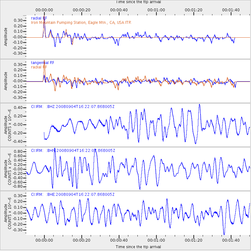
IRM Iron Mountain Pumping Station, Eagle Mtn., CA, USA - Earthquake Result Viewer
*The percent match for this event was below the threshold and hence no stack was calculated.
| Earthquake location: |
Kermadec Islands Region |
| Earthquake latitude/longitude: |
-31.6/-177.8 |
| Earthquake time(UTC): |
2008/09/04 (248) 16:09:51 GMT |
| Earthquake Depth: |
26 km |
| Earthquake Magnitude: |
5.5 MB, 5.9 MS, 5.8 MW, 5.7 MW |
| Earthquake Catalog/Contributor: |
WHDF/NEIC |
|
| Network: |
CI Caltech Regional Seismic Network |
| Station: |
IRM Iron Mountain Pumping Station, Eagle Mtn., CA, USA |
| Lat/Lon: |
34.16 N/115.15 W |
| Elevation: |
567 m |
|
| Distance: |
88.0 deg |
| Az: |
47.481 deg |
| Baz: |
229.357 deg |
| Ray Param: |
$rayparam |
*The percent match for this event was below the threshold and hence was not used in the summary stack. |
|
| Radial Match: |
59.436695 % |
| Radial Bump: |
400 |
| Transverse Match: |
52.34512 % |
| Transverse Bump: |
400 |
| SOD ConfigId: |
2504 |
| Insert Time: |
2010-02-26 01:49:26.721 +0000 |
| GWidth: |
2.5 |
| Max Bumps: |
400 |
| Tol: |
0.001 |
|
Signal To Noise
| Channel | StoN | STA | LTA |
| CI:IRM: :BHN:20080904T16:22:07.868005Z | 2.2788863 | 2.892912E-7 | 1.2694412E-7 |
| CI:IRM: :BHE:20080904T16:22:07.868005Z | 1.0766873 | 1.17817216E-7 | 1.0942565E-7 |
| CI:IRM: :BHZ:20080904T16:22:07.868005Z | 0.8844191 | 1.10720094E-7 | 1.2518963E-7 |
| Arrivals |
| Ps | |
| PpPs | |
| PsPs/PpSs | |


