You are here: Home > Network List > TA - USArray Transportable Network (new EarthScope stations) Stations List
> Station G21K Allakaket, AK, USA > Earthquake Result Viewer
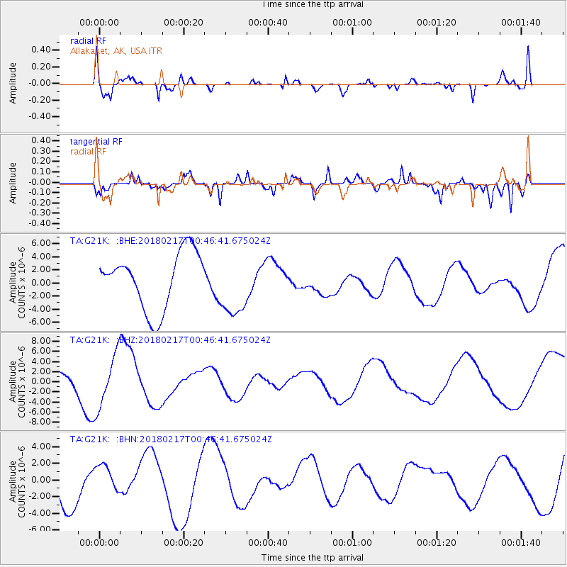
G21K Allakaket, AK, USA - Earthquake Result Viewer
*The percent match for this event was below the threshold and hence no stack was calculated.
| Earthquake location: |
Oaxaca, Mexico |
| Earthquake latitude/longitude: |
16.2/-97.8 |
| Earthquake time(UTC): |
2018/02/17 (048) 00:36:53 GMT |
| Earthquake Depth: |
8.9 km |
| Earthquake Magnitude: |
5.8 Mww |
| Earthquake Catalog/Contributor: |
NEIC PDE/us |
|
| Network: |
TA USArray Transportable Network (new EarthScope stations) |
| Station: |
G21K Allakaket, AK, USA |
| Lat/Lon: |
66.52 N/153.51 W |
| Elevation: |
446 m |
|
| Distance: |
61.9 deg |
| Az: |
337.945 deg |
| Baz: |
115.814 deg |
| Ray Param: |
$rayparam |
*The percent match for this event was below the threshold and hence was not used in the summary stack. |
|
| Radial Match: |
48.741146 % |
| Radial Bump: |
382 |
| Transverse Match: |
61.057926 % |
| Transverse Bump: |
350 |
| SOD ConfigId: |
13570011 |
| Insert Time: |
2019-04-29 20:18:51.784 +0000 |
| GWidth: |
2.5 |
| Max Bumps: |
400 |
| Tol: |
0.001 |
|
Signal To Noise
| Channel | StoN | STA | LTA |
| TA:G21K: :BHZ:20180217T00:46:41.675024Z | 3.114093 | 5.2357823E-6 | 1.6813185E-6 |
| TA:G21K: :BHN:20180217T00:46:41.675024Z | 0.63519037 | 1.7024829E-6 | 2.6802718E-6 |
| TA:G21K: :BHE:20180217T00:46:41.675024Z | 1.1050984 | 4.6899227E-6 | 4.2438965E-6 |
| Arrivals |
| Ps | |
| PpPs | |
| PsPs/PpSs | |


