You are here: Home > Network List > TA - USArray Transportable Network (new EarthScope stations) Stations List
> Station M11K Mekoryuk, AK, USA > Earthquake Result Viewer
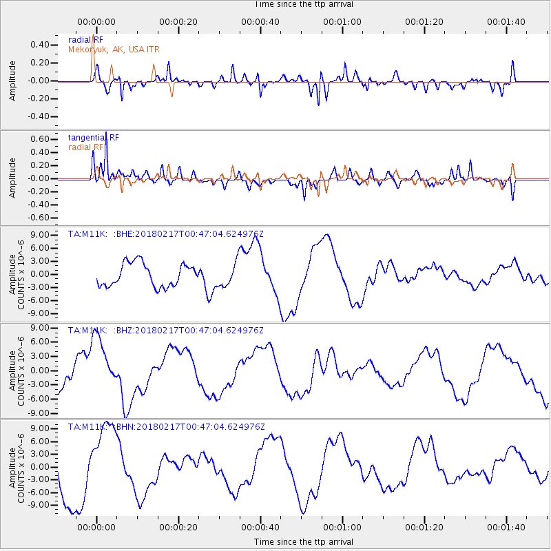
M11K Mekoryuk, AK, USA - Earthquake Result Viewer
*The percent match for this event was below the threshold and hence no stack was calculated.
| Earthquake location: |
Oaxaca, Mexico |
| Earthquake latitude/longitude: |
16.2/-97.8 |
| Earthquake time(UTC): |
2018/02/17 (048) 00:36:53 GMT |
| Earthquake Depth: |
8.9 km |
| Earthquake Magnitude: |
5.8 Mww |
| Earthquake Catalog/Contributor: |
NEIC PDE/us |
|
| Network: |
TA USArray Transportable Network (new EarthScope stations) |
| Station: |
M11K Mekoryuk, AK, USA |
| Lat/Lon: |
60.38 N/166.20 W |
| Elevation: |
3.0 m |
|
| Distance: |
65.4 deg |
| Az: |
329.468 deg |
| Baz: |
100.68 deg |
| Ray Param: |
$rayparam |
*The percent match for this event was below the threshold and hence was not used in the summary stack. |
|
| Radial Match: |
52.707233 % |
| Radial Bump: |
382 |
| Transverse Match: |
78.18133 % |
| Transverse Bump: |
400 |
| SOD ConfigId: |
13570011 |
| Insert Time: |
2019-04-29 20:19:03.705 +0000 |
| GWidth: |
2.5 |
| Max Bumps: |
400 |
| Tol: |
0.001 |
|
Signal To Noise
| Channel | StoN | STA | LTA |
| TA:M11K: :BHZ:20180217T00:47:04.624976Z | 2.1170647 | 5.9253134E-6 | 2.7988342E-6 |
| TA:M11K: :BHN:20180217T00:47:04.624976Z | 1.6732699 | 9.319472E-6 | 5.5696173E-6 |
| TA:M11K: :BHE:20180217T00:47:04.624976Z | 1.3955535 | 3.6161616E-6 | 2.5912025E-6 |
| Arrivals |
| Ps | |
| PpPs | |
| PsPs/PpSs | |


