You are here: Home > Network List > TA - USArray Transportable Network (new EarthScope stations) Stations List
> Station Y12C Blythe, CA, USA > Earthquake Result Viewer
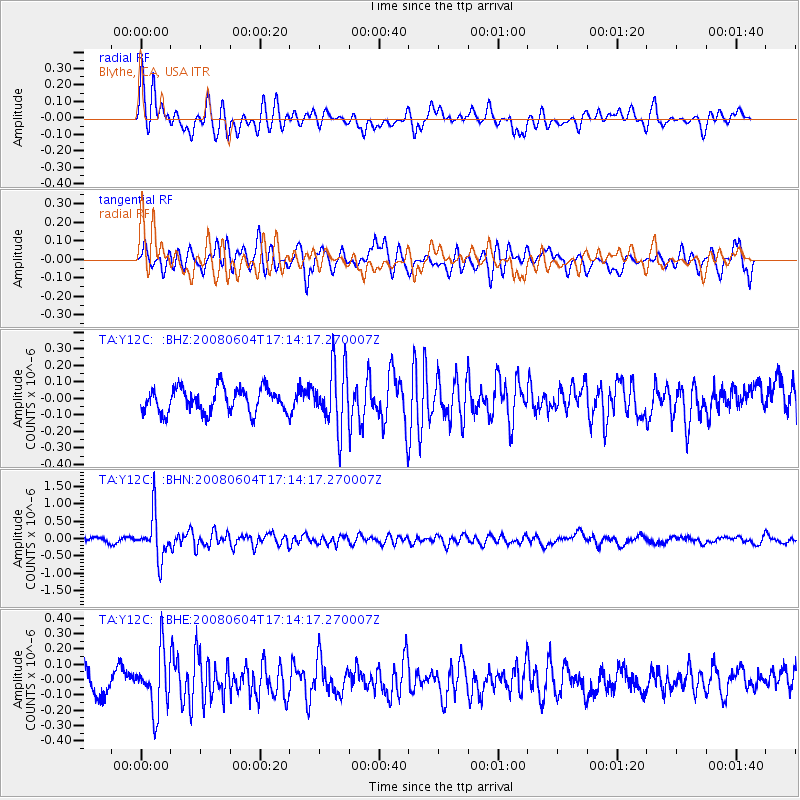
Y12C Blythe, CA, USA - Earthquake Result Viewer
*The percent match for this event was below the threshold and hence no stack was calculated.
| Earthquake location: |
Hokkaido, Japan Region |
| Earthquake latitude/longitude: |
41.5/139.0 |
| Earthquake time(UTC): |
2008/06/04 (156) 17:03:07 GMT |
| Earthquake Depth: |
213 km |
| Earthquake Magnitude: |
5.5 MB, 5.7 MW, 5.7 MW |
| Earthquake Catalog/Contributor: |
WHDF/NEIC |
|
| Network: |
TA USArray Transportable Network (new EarthScope stations) |
| Station: |
Y12C Blythe, CA, USA |
| Lat/Lon: |
33.75 N/114.52 W |
| Elevation: |
196 m |
|
| Distance: |
79.1 deg |
| Az: |
54.463 deg |
| Baz: |
312.841 deg |
| Ray Param: |
$rayparam |
*The percent match for this event was below the threshold and hence was not used in the summary stack. |
|
| Radial Match: |
67.8552 % |
| Radial Bump: |
400 |
| Transverse Match: |
64.18128 % |
| Transverse Bump: |
400 |
| SOD ConfigId: |
2504 |
| Insert Time: |
2010-03-06 09:13:20.612 +0000 |
| GWidth: |
2.5 |
| Max Bumps: |
400 |
| Tol: |
0.001 |
|
Signal To Noise
| Channel | StoN | STA | LTA |
| TA:Y12C: :BHN:20080604T17:14:17.270007Z | 9.367235 | 6.370042E-7 | 6.800344E-8 |
| TA:Y12C: :BHE:20080604T17:14:17.270007Z | 1.8742946 | 1.8784887E-7 | 1.0022377E-7 |
| TA:Y12C: :BHZ:20080604T17:14:17.270007Z | 2.5885851 | 1.8992684E-7 | 7.3370906E-8 |
| Arrivals |
| Ps | |
| PpPs | |
| PsPs/PpSs | |


