You are here: Home > Network List > TA - USArray Transportable Network (new EarthScope stations) Stations List
> Station Y12C Blythe, CA, USA > Earthquake Result Viewer
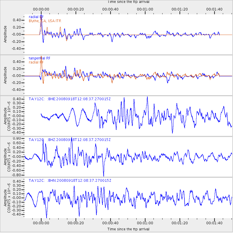
Y12C Blythe, CA, USA - Earthquake Result Viewer
*The percent match for this event was below the threshold and hence no stack was calculated.
| Earthquake location: |
Near East Coast Of Kamchatka |
| Earthquake latitude/longitude: |
51.9/158.4 |
| Earthquake time(UTC): |
2008/09/18 (262) 11:58:50 GMT |
| Earthquake Depth: |
67 km |
| Earthquake Magnitude: |
5.7 MB, 5.9 MW, 5.8 MW |
| Earthquake Catalog/Contributor: |
WHDF/NEIC |
|
| Network: |
TA USArray Transportable Network (new EarthScope stations) |
| Station: |
Y12C Blythe, CA, USA |
| Lat/Lon: |
33.75 N/114.52 W |
| Elevation: |
196 m |
|
| Distance: |
62.6 deg |
| Az: |
69.611 deg |
| Baz: |
315.833 deg |
| Ray Param: |
$rayparam |
*The percent match for this event was below the threshold and hence was not used in the summary stack. |
|
| Radial Match: |
73.7927 % |
| Radial Bump: |
400 |
| Transverse Match: |
66.12984 % |
| Transverse Bump: |
400 |
| SOD ConfigId: |
2504 |
| Insert Time: |
2010-03-06 09:13:39.373 +0000 |
| GWidth: |
2.5 |
| Max Bumps: |
400 |
| Tol: |
0.001 |
|
Signal To Noise
| Channel | StoN | STA | LTA |
| TA:Y12C: :BHZ:20080918T12:08:37.270015Z | 2.9545922 | 3.0161598E-7 | 1.02083796E-7 |
| TA:Y12C: :BHN:20080918T12:08:37.270015Z | 3.0125425 | 1.8412484E-7 | 6.1119415E-8 |
| TA:Y12C: :BHE:20080918T12:08:37.270015Z | 1.7062879 | 1.5808901E-7 | 9.265084E-8 |
| Arrivals |
| Ps | |
| PpPs | |
| PsPs/PpSs | |


