You are here: Home > Network List > TA - USArray Transportable Network (new EarthScope stations) Stations List
> Station F26K Sheenjek River, AK, USA > Earthquake Result Viewer
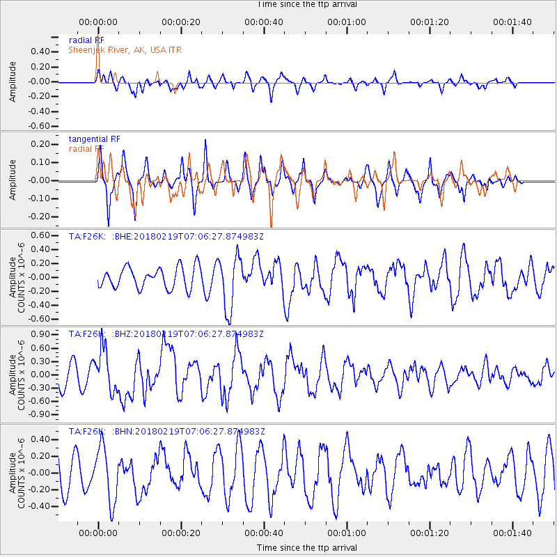
F26K Sheenjek River, AK, USA - Earthquake Result Viewer
*The percent match for this event was below the threshold and hence no stack was calculated.
| Earthquake location: |
Oaxaca, Mexico |
| Earthquake latitude/longitude: |
16.5/-97.6 |
| Earthquake time(UTC): |
2018/02/19 (050) 06:57:01 GMT |
| Earthquake Depth: |
40 km |
| Earthquake Magnitude: |
5.9 Mww |
| Earthquake Catalog/Contributor: |
NEIC PDE/us |
|
| Network: |
TA USArray Transportable Network (new EarthScope stations) |
| Station: |
F26K Sheenjek River, AK, USA |
| Lat/Lon: |
67.69 N/144.15 W |
| Elevation: |
683 m |
|
| Distance: |
59.2 deg |
| Az: |
341.164 deg |
| Baz: |
125.769 deg |
| Ray Param: |
$rayparam |
*The percent match for this event was below the threshold and hence was not used in the summary stack. |
|
| Radial Match: |
56.82152 % |
| Radial Bump: |
383 |
| Transverse Match: |
53.571655 % |
| Transverse Bump: |
294 |
| SOD ConfigId: |
13570011 |
| Insert Time: |
2019-04-29 20:26:10.603 +0000 |
| GWidth: |
2.5 |
| Max Bumps: |
400 |
| Tol: |
0.001 |
|
Signal To Noise
| Channel | StoN | STA | LTA |
| TA:F26K: :BHZ:20180219T07:06:27.874983Z | 2.0531476 | 4.844705E-7 | 2.3596475E-7 |
| TA:F26K: :BHN:20180219T07:06:27.874983Z | 1.0566204 | 3.383846E-7 | 3.2025181E-7 |
| TA:F26K: :BHE:20180219T07:06:27.874983Z | 2.6222372 | 3.8959462E-7 | 1.4857336E-7 |
| Arrivals |
| Ps | |
| PpPs | |
| PsPs/PpSs | |


