You are here: Home > Network List > TA - USArray Transportable Network (new EarthScope stations) Stations List
> Station L15K Ungalak Mountain, AK, USA > Earthquake Result Viewer
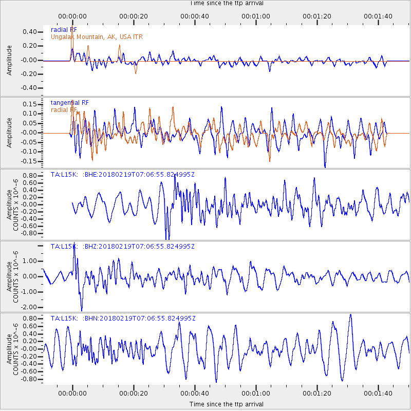
L15K Ungalak Mountain, AK, USA - Earthquake Result Viewer
*The percent match for this event was below the threshold and hence no stack was calculated.
| Earthquake location: |
Oaxaca, Mexico |
| Earthquake latitude/longitude: |
16.5/-97.6 |
| Earthquake time(UTC): |
2018/02/19 (050) 06:57:01 GMT |
| Earthquake Depth: |
40 km |
| Earthquake Magnitude: |
5.9 Mww |
| Earthquake Catalog/Contributor: |
NEIC PDE/us |
|
| Network: |
TA USArray Transportable Network (new EarthScope stations) |
| Station: |
L15K Ungalak Mountain, AK, USA |
| Lat/Lon: |
61.68 N/161.49 W |
| Elevation: |
219 m |
|
| Distance: |
63.3 deg |
| Az: |
331.353 deg |
| Baz: |
105.334 deg |
| Ray Param: |
$rayparam |
*The percent match for this event was below the threshold and hence was not used in the summary stack. |
|
| Radial Match: |
54.20133 % |
| Radial Bump: |
400 |
| Transverse Match: |
56.9052 % |
| Transverse Bump: |
385 |
| SOD ConfigId: |
13570011 |
| Insert Time: |
2019-04-29 20:26:49.558 +0000 |
| GWidth: |
2.5 |
| Max Bumps: |
400 |
| Tol: |
0.001 |
|
Signal To Noise
| Channel | StoN | STA | LTA |
| TA:L15K: :BHZ:20180219T07:06:55.824995Z | 2.376201 | 1.0277938E-6 | 4.3253658E-7 |
| TA:L15K: :BHN:20180219T07:06:55.824995Z | 0.93967855 | 2.446041E-7 | 2.6030614E-7 |
| TA:L15K: :BHE:20180219T07:06:55.824995Z | 2.429681 | 5.185507E-7 | 2.1342335E-7 |
| Arrivals |
| Ps | |
| PpPs | |
| PsPs/PpSs | |


