You are here: Home > Network List > TA - USArray Transportable Network (new EarthScope stations) Stations List
> Station Y12C Blythe, CA, USA > Earthquake Result Viewer
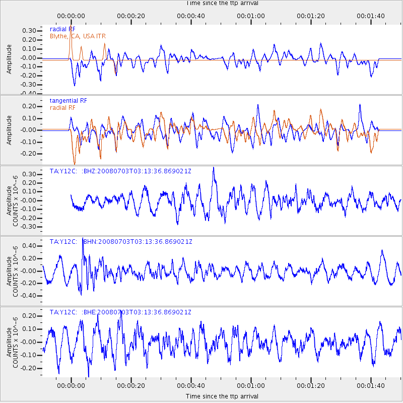
Y12C Blythe, CA, USA - Earthquake Result Viewer
*The percent match for this event was below the threshold and hence no stack was calculated.
| Earthquake location: |
South Of Fiji Islands |
| Earthquake latitude/longitude: |
-23.4/-179.8 |
| Earthquake time(UTC): |
2008/07/03 (185) 03:02:37 GMT |
| Earthquake Depth: |
581 km |
| Earthquake Magnitude: |
5.6 MB, 6.2 MW, 6.2 MW |
| Earthquake Catalog/Contributor: |
WHDF/NEIC |
|
| Network: |
TA USArray Transportable Network (new EarthScope stations) |
| Station: |
Y12C Blythe, CA, USA |
| Lat/Lon: |
33.75 N/114.52 W |
| Elevation: |
196 m |
|
| Distance: |
84.1 deg |
| Az: |
49.524 deg |
| Baz: |
237.03 deg |
| Ray Param: |
$rayparam |
*The percent match for this event was below the threshold and hence was not used in the summary stack. |
|
| Radial Match: |
53.612408 % |
| Radial Bump: |
400 |
| Transverse Match: |
40.6948 % |
| Transverse Bump: |
400 |
| SOD ConfigId: |
2504 |
| Insert Time: |
2010-03-06 09:15:28.335 +0000 |
| GWidth: |
2.5 |
| Max Bumps: |
400 |
| Tol: |
0.001 |
|
Signal To Noise
| Channel | StoN | STA | LTA |
| TA:Y12C: :BHN:20080703T03:13:36.869021Z | 2.955035 | 2.1128716E-7 | 7.150073E-8 |
| TA:Y12C: :BHE:20080703T03:13:36.869021Z | 1.6607507 | 9.681858E-8 | 5.829808E-8 |
| TA:Y12C: :BHZ:20080703T03:13:36.869021Z | 0.99292606 | 6.611974E-8 | 6.65908E-8 |
| Arrivals |
| Ps | |
| PpPs | |
| PsPs/PpSs | |


