You are here: Home > Network List > TA - USArray Transportable Network (new EarthScope stations) Stations List
> Station Y12C Blythe, CA, USA > Earthquake Result Viewer
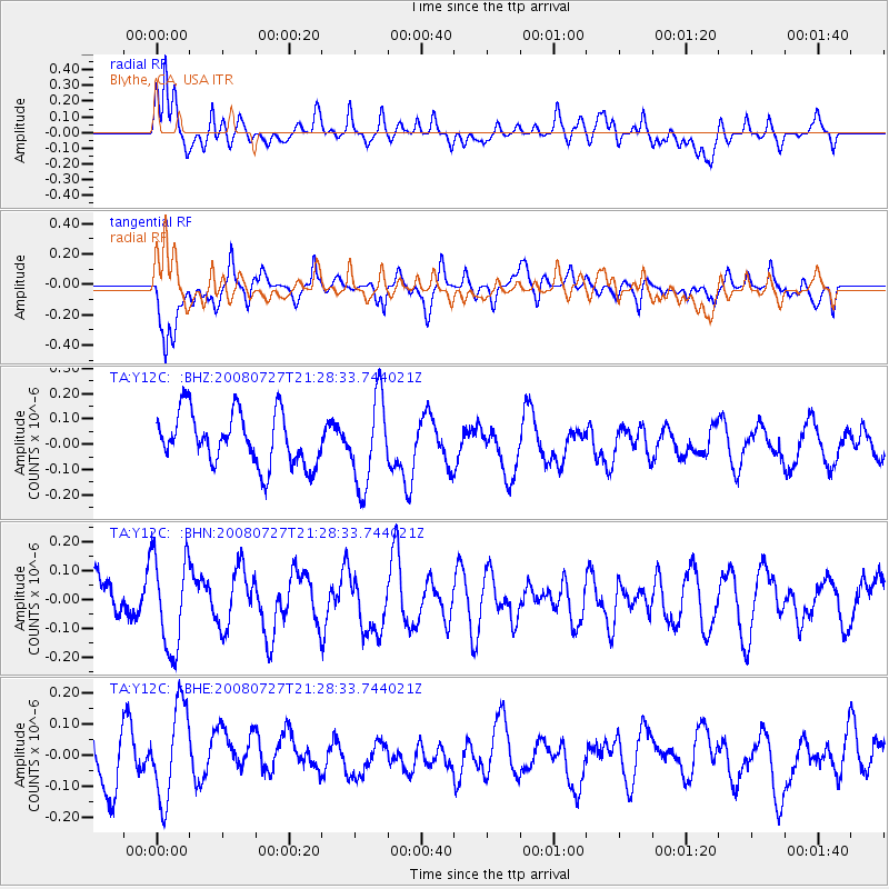
Y12C Blythe, CA, USA - Earthquake Result Viewer
*The percent match for this event was below the threshold and hence no stack was calculated.
| Earthquake location: |
Central Mid-Atlantic Ridge |
| Earthquake latitude/longitude: |
-0.3/-18.3 |
| Earthquake time(UTC): |
2008/07/27 (209) 21:15:41 GMT |
| Earthquake Depth: |
10 km |
| Earthquake Magnitude: |
5.8 MB, 5.3 MS, 5.9 MW, 5.8 MW |
| Earthquake Catalog/Contributor: |
WHDF/NEIC |
|
| Network: |
TA USArray Transportable Network (new EarthScope stations) |
| Station: |
Y12C Blythe, CA, USA |
| Lat/Lon: |
33.75 N/114.52 W |
| Elevation: |
196 m |
|
| Distance: |
95.3 deg |
| Az: |
303.71 deg |
| Baz: |
86.76 deg |
| Ray Param: |
$rayparam |
*The percent match for this event was below the threshold and hence was not used in the summary stack. |
|
| Radial Match: |
56.257282 % |
| Radial Bump: |
400 |
| Transverse Match: |
59.008 % |
| Transverse Bump: |
400 |
| SOD ConfigId: |
2504 |
| Insert Time: |
2010-03-06 09:15:29.574 +0000 |
| GWidth: |
2.5 |
| Max Bumps: |
400 |
| Tol: |
0.001 |
|
Signal To Noise
| Channel | StoN | STA | LTA |
| TA:Y12C: :BHN:20080727T21:28:33.744021Z | 1.6267455 | 1.6328381E-7 | 1.00374535E-7 |
| TA:Y12C: :BHE:20080727T21:28:33.744021Z | 1.203592 | 1.5304336E-7 | 1.2715552E-7 |
| TA:Y12C: :BHZ:20080727T21:28:33.744021Z | 1.6765298 | 1.7207263E-7 | 1.026362E-7 |
| Arrivals |
| Ps | |
| PpPs | |
| PsPs/PpSs | |


