You are here: Home > Network List > TA - USArray Transportable Network (new EarthScope stations) Stations List
> Station 112A Yuma, AZ, USA > Earthquake Result Viewer
112A Yuma, AZ, USA - Earthquake Result Viewer
| Earthquake location: |
Kuril Islands |
| Earthquake latitude/longitude: |
51.0/157.6 |
| Earthquake time(UTC): |
2008/07/24 (206) 01:43:16 GMT |
| Earthquake Depth: |
27 km |
| Earthquake Magnitude: |
6.0 MB, 6.0 MS, 6.2 MW, 6.2 MW |
| Earthquake Catalog/Contributor: |
WHDF/NEIC |
|
| Network: |
TA USArray Transportable Network (new EarthScope stations) |
| Station: |
112A Yuma, AZ, USA |
| Lat/Lon: |
32.54 N/114.58 W |
| Elevation: |
87 m |
|
| Distance: |
64.2 deg |
| Az: |
69.61 deg |
| Baz: |
315.438 deg |
| Ray Param: |
0.059020378 |
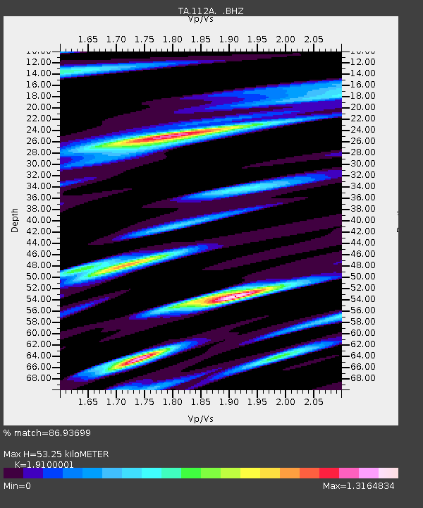
| Estimated Moho Depth: |
53.25 km |
| Estimated Crust Vp/Vs: |
1.91 |
| Assumed Crust Vp: |
6.155 km/s |
| Estimated Crust Vs: |
3.222 km/s |
| Estimated Crust Poisson's Ratio: |
0.31 |
|
| Radial Match: |
86.93699 % |
| Radial Bump: |
400 |
| Transverse Match: |
73.41818 % |
| Transverse Bump: |
400 |
| SOD ConfigId: |
2504 |
| Insert Time: |
2010-03-06 09:16:04.696 +0000 |
| GWidth: |
2.5 |
| Max Bumps: |
400 |
| Tol: |
0.001 |
|
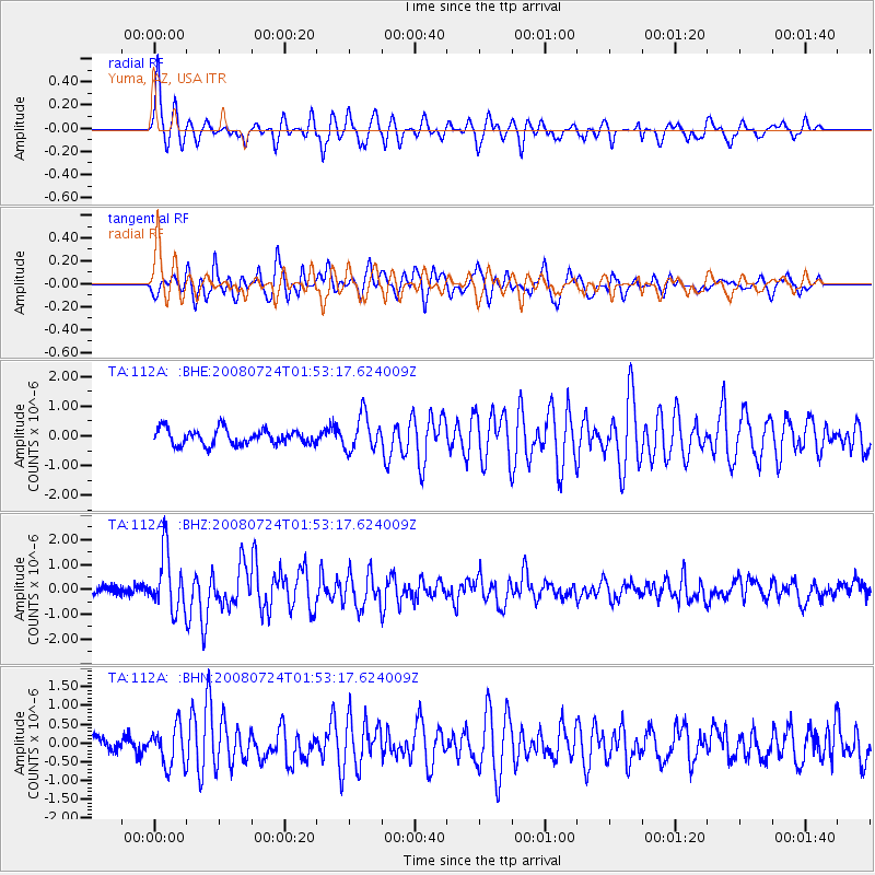
Signal To Noise
| Channel | StoN | STA | LTA |
| TA:112A: :BHZ:20080724T01:53:17.624009Z | 6.8335466 | 1.1632495E-6 | 1.7022631E-7 |
| TA:112A: :BHN:20080724T01:53:17.624009Z | 2.0586462 | 5.192682E-7 | 2.522377E-7 |
| TA:112A: :BHE:20080724T01:53:17.624009Z | 2.2945213 | 5.9196344E-7 | 2.5798997E-7 |
| Arrivals |
| Ps | 8.2 SECOND |
| PpPs | 24 SECOND |
| PsPs/PpSs | 32 SECOND |


