You are here: Home > Network List > US - United States National Seismic Network Stations List
> Station DGMT Dagmar, Montana, USA > Earthquake Result Viewer
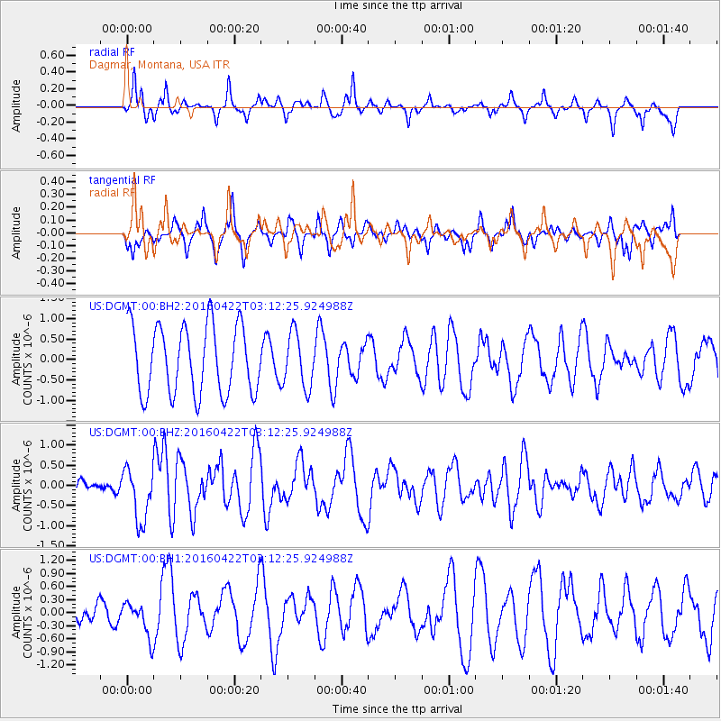
DGMT Dagmar, Montana, USA - Earthquake Result Viewer
*The percent match for this event was below the threshold and hence no stack was calculated.
| Earthquake location: |
Near Coast Of Ecuador |
| Earthquake latitude/longitude: |
-0.3/-80.5 |
| Earthquake time(UTC): |
2016/04/22 (113) 03:03:42 GMT |
| Earthquake Depth: |
10 km |
| Earthquake Magnitude: |
6.0 MO |
| Earthquake Catalog/Contributor: |
NEIC PDE/NEIC ALERT |
|
| Network: |
US United States National Seismic Network |
| Station: |
DGMT Dagmar, Montana, USA |
| Lat/Lon: |
48.47 N/104.20 W |
| Elevation: |
0.0 m |
|
| Distance: |
52.7 deg |
| Az: |
340.401 deg |
| Baz: |
149.734 deg |
| Ray Param: |
$rayparam |
*The percent match for this event was below the threshold and hence was not used in the summary stack. |
|
| Radial Match: |
70.06707 % |
| Radial Bump: |
361 |
| Transverse Match: |
45.817654 % |
| Transverse Bump: |
371 |
| SOD ConfigId: |
1475611 |
| Insert Time: |
2016-05-06 03:12:56.227 +0000 |
| GWidth: |
2.5 |
| Max Bumps: |
400 |
| Tol: |
0.001 |
|
Signal To Noise
| Channel | StoN | STA | LTA |
| US:DGMT:00:BHZ:20160422T03:12:25.924988Z | 3.514426 | 6.6819734E-7 | 1.9012985E-7 |
| US:DGMT:00:BH1:20160422T03:12:25.924988Z | 1.4509916 | 4.0593162E-7 | 2.7976154E-7 |
| US:DGMT:00:BH2:20160422T03:12:25.924988Z | 0.79468185 | 6.6190285E-7 | 8.3291553E-7 |
| Arrivals |
| Ps | |
| PpPs | |
| PsPs/PpSs | |


