You are here: Home > Network List > TA - USArray Transportable Network (new EarthScope stations) Stations List
> Station B18K Kokolik River, AK, USA > Earthquake Result Viewer
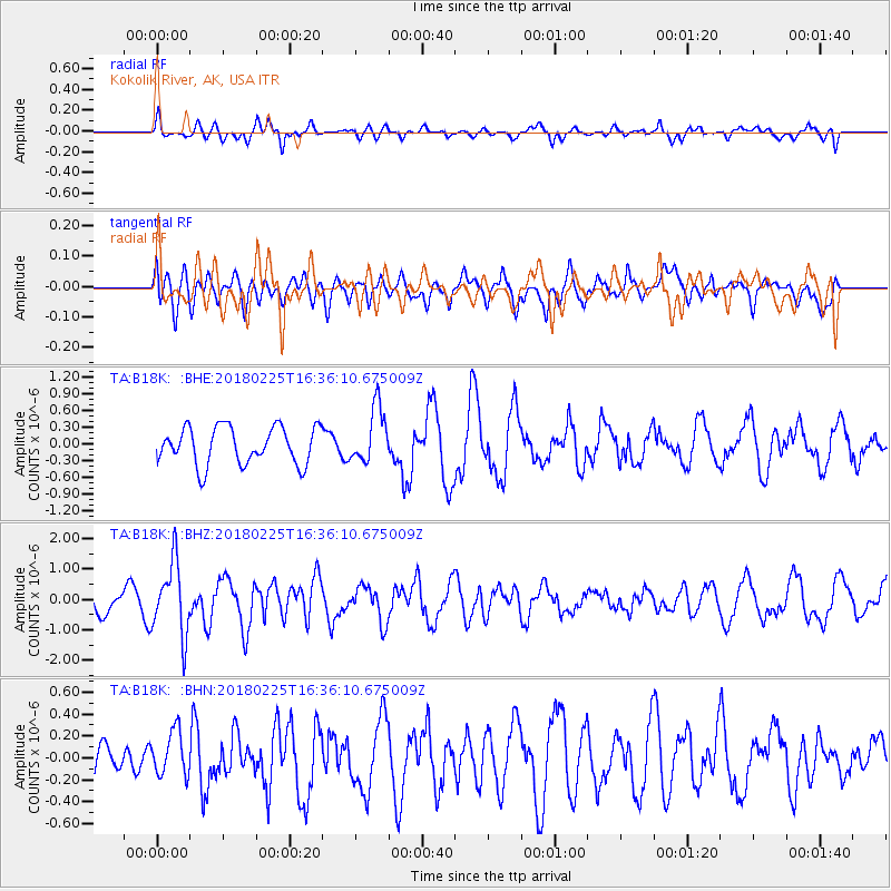
B18K Kokolik River, AK, USA - Earthquake Result Viewer
*The percent match for this event was below the threshold and hence no stack was calculated.
| Earthquake location: |
Near East Coast Of Honshu, Japan |
| Earthquake latitude/longitude: |
37.6/141.7 |
| Earthquake time(UTC): |
2018/02/25 (056) 16:28:39 GMT |
| Earthquake Depth: |
31 km |
| Earthquake Magnitude: |
5.6 Mww |
| Earthquake Catalog/Contributor: |
NEIC PDE/us |
|
| Network: |
TA USArray Transportable Network (new EarthScope stations) |
| Station: |
B18K Kokolik River, AK, USA |
| Lat/Lon: |
69.36 N/161.80 W |
| Elevation: |
222 m |
|
| Distance: |
43.6 deg |
| Az: |
25.345 deg |
| Baz: |
253.578 deg |
| Ray Param: |
$rayparam |
*The percent match for this event was below the threshold and hence was not used in the summary stack. |
|
| Radial Match: |
57.42756 % |
| Radial Bump: |
400 |
| Transverse Match: |
44.862183 % |
| Transverse Bump: |
400 |
| SOD ConfigId: |
13570011 |
| Insert Time: |
2019-04-29 20:35:18.621 +0000 |
| GWidth: |
2.5 |
| Max Bumps: |
400 |
| Tol: |
0.001 |
|
Signal To Noise
| Channel | StoN | STA | LTA |
| TA:B18K: :BHZ:20180225T16:36:10.675009Z | 3.8042543 | 1.1962658E-6 | 3.1445475E-7 |
| TA:B18K: :BHN:20180225T16:36:10.675009Z | 0.64113414 | 2.0729163E-7 | 3.2332025E-7 |
| TA:B18K: :BHE:20180225T16:36:10.675009Z | 1.488592 | 5.010605E-7 | 3.366003E-7 |
| Arrivals |
| Ps | |
| PpPs | |
| PsPs/PpSs | |


