You are here: Home > Network List > TA - USArray Transportable Network (new EarthScope stations) Stations List
> Station D23K Nanushuk River, AK USA > Earthquake Result Viewer
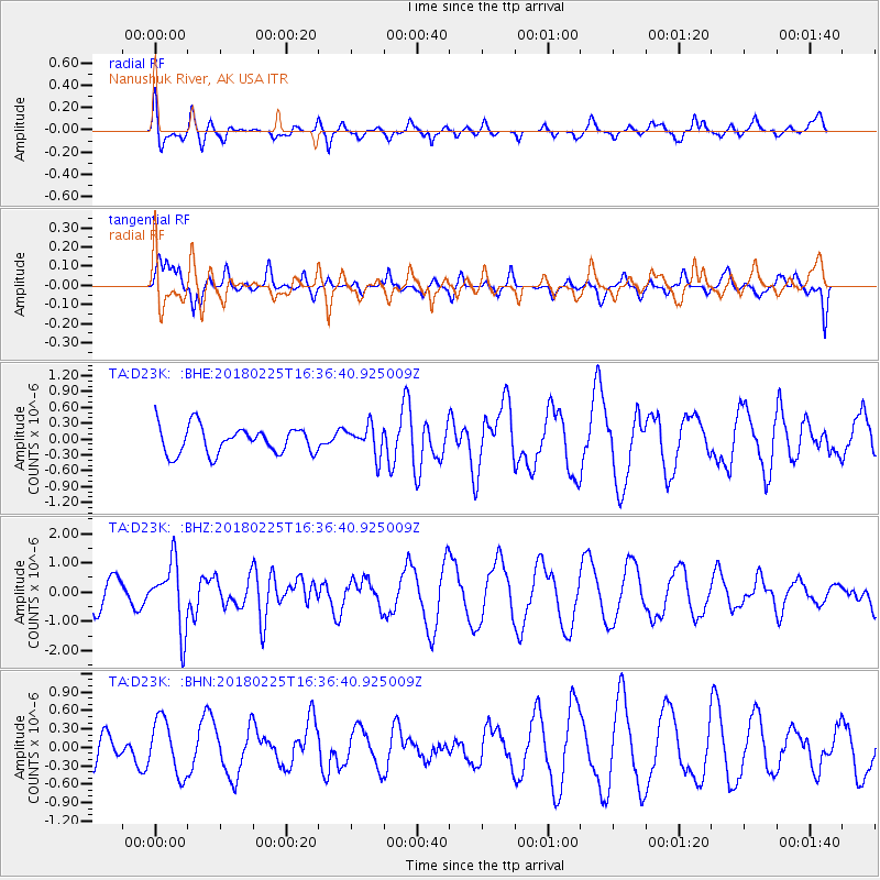
D23K Nanushuk River, AK USA - Earthquake Result Viewer
*The percent match for this event was below the threshold and hence no stack was calculated.
| Earthquake location: |
Near East Coast Of Honshu, Japan |
| Earthquake latitude/longitude: |
37.6/141.7 |
| Earthquake time(UTC): |
2018/02/25 (056) 16:28:39 GMT |
| Earthquake Depth: |
31 km |
| Earthquake Magnitude: |
5.6 Mww |
| Earthquake Catalog/Contributor: |
NEIC PDE/us |
|
| Network: |
TA USArray Transportable Network (new EarthScope stations) |
| Station: |
D23K Nanushuk River, AK USA |
| Lat/Lon: |
68.97 N/150.68 W |
| Elevation: |
406 m |
|
| Distance: |
47.5 deg |
| Az: |
26.924 deg |
| Baz: |
265.073 deg |
| Ray Param: |
$rayparam |
*The percent match for this event was below the threshold and hence was not used in the summary stack. |
|
| Radial Match: |
55.60286 % |
| Radial Bump: |
400 |
| Transverse Match: |
70.25792 % |
| Transverse Bump: |
346 |
| SOD ConfigId: |
13570011 |
| Insert Time: |
2019-04-29 20:35:26.848 +0000 |
| GWidth: |
2.5 |
| Max Bumps: |
400 |
| Tol: |
0.001 |
|
Signal To Noise
| Channel | StoN | STA | LTA |
| TA:D23K: :BHZ:20180225T16:36:40.925009Z | 2.762601 | 1.1308134E-6 | 4.0932923E-7 |
| TA:D23K: :BHN:20180225T16:36:40.925009Z | 1.8964304 | 4.480598E-7 | 2.3626482E-7 |
| TA:D23K: :BHE:20180225T16:36:40.925009Z | 1.0981857 | 2.8143842E-7 | 2.5627583E-7 |
| Arrivals |
| Ps | |
| PpPs | |
| PsPs/PpSs | |


