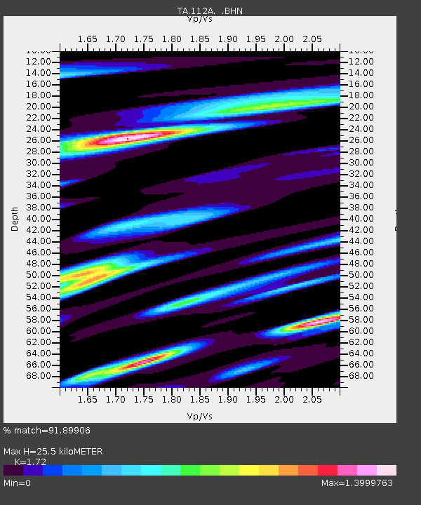
112A Yuma, AZ, USA - Earthquake Result Viewer
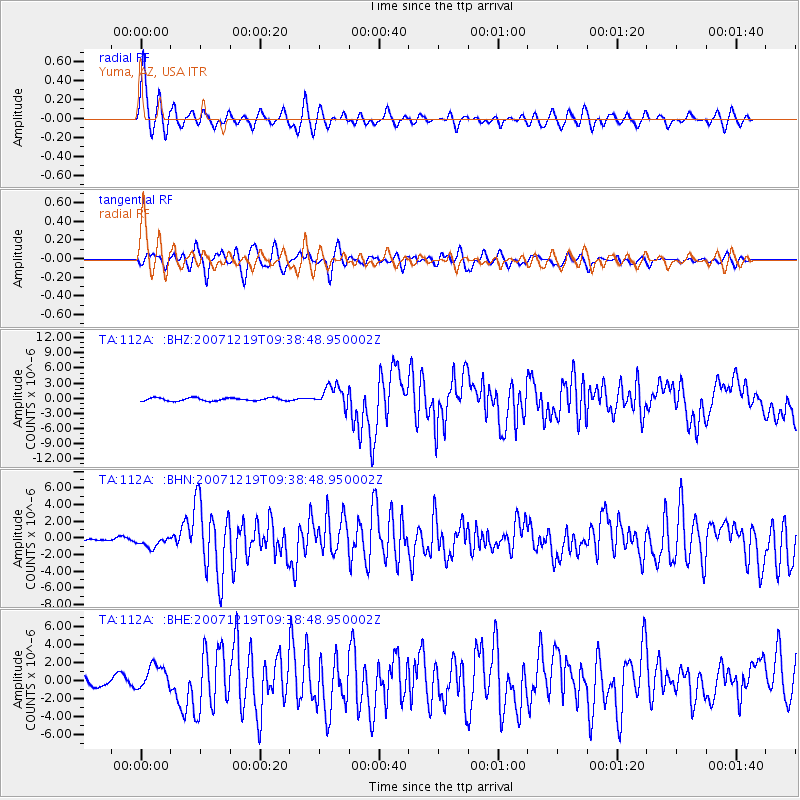
Earthquake location: Andreanof Islands, Aleutian Is.
Earthquake latitude/longitude: 51.4/-179.5
Earthquake time(UTC): 2007/12/19 (353) 09:30:27 GMT
Earthquake Depth: 29 km
Earthquake Magnitude: 6.4 MB, 7.1 MS, 7.1 MW, 7.0 MW
Earthquake Catalog/Contributor: WHDF/NEIC
Network: TA USArray Transportable Network (new EarthScope stations)
Station: 112A Yuma, AZ, USA
Lat/Lon: 32.54 N/114.58 W
Elevation: 87 m
Distance: 50.1 deg
Az: 85.751 deg
Baz: 312.254 deg
Ray Param: 0.06822039
Estimated Moho Depth: 25.5 km
Estimated Crust Vp/Vs: 1.72
Assumed Crust Vp: 6.155 km/s
Estimated Crust Vs: 3.578 km/s
Estimated Crust Poisson's Ratio: 0.24
Radial Match: 91.89906 %
Radial Bump: 400
Transverse Match: 76.16852 %
Transverse Bump: 400
SOD ConfigId: 2564
Insert Time: 2010-03-06 09:16:24.342 +0000
GWidth: 2.5
Max Bumps: 400
Tol: 0.001

Signal To Noise

ChannelStoNSTALTA
TA:112A: :BHN:20071219T09:38:48.950002Z1.00209466.777571E-76.7634045E-7
TA:112A: :BHE:20071219T09:38:48.950002Z2.11337921.3612417E-66.441067E-7
TA:112A: :BHZ:20071219T09:38:48.950002Z6.80243872.0487619E-63.011805E-7
Arrivals
Ps3.2 SECOND
PpPs11 SECOND
PsPs/PpSs14 SECOND