You are here: Home > Network List > US - United States National Seismic Network Stations List
> Station GLMI Grayling, Michigan, USA > Earthquake Result Viewer
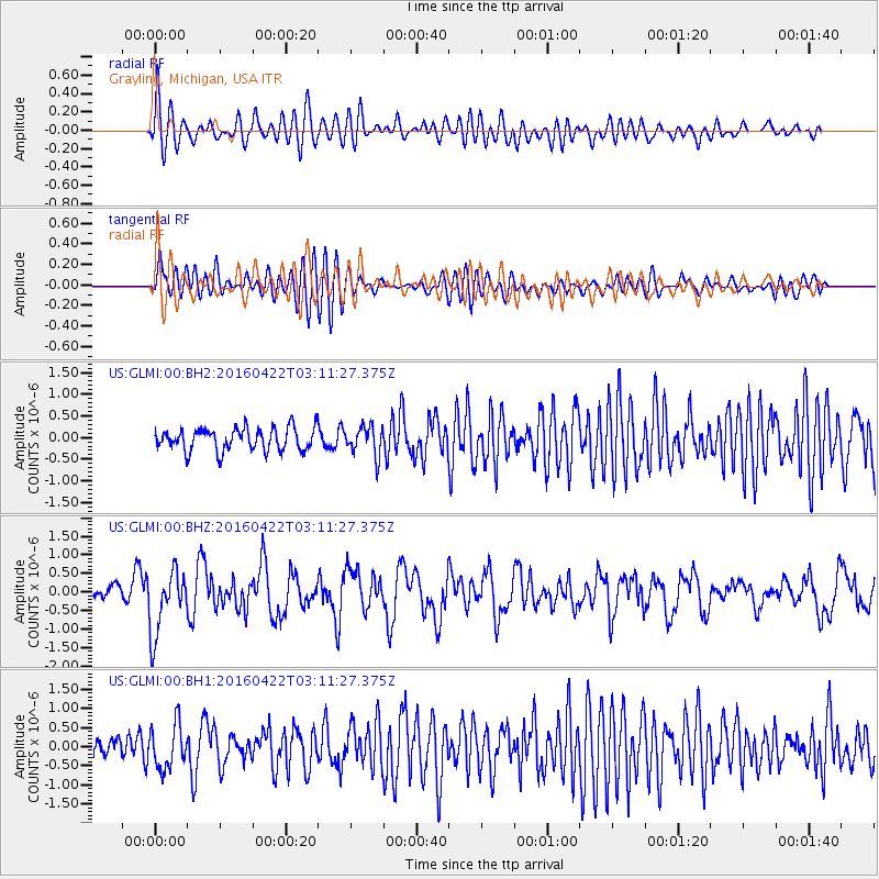
GLMI Grayling, Michigan, USA - Earthquake Result Viewer
*The percent match for this event was below the threshold and hence no stack was calculated.
| Earthquake location: |
Near Coast Of Ecuador |
| Earthquake latitude/longitude: |
-0.3/-80.5 |
| Earthquake time(UTC): |
2016/04/22 (113) 03:03:42 GMT |
| Earthquake Depth: |
10 km |
| Earthquake Magnitude: |
6.0 MO |
| Earthquake Catalog/Contributor: |
NEIC PDE/NEIC ALERT |
|
| Network: |
US United States National Seismic Network |
| Station: |
GLMI Grayling, Michigan, USA |
| Lat/Lon: |
44.82 N/84.62 W |
| Elevation: |
387 m |
|
| Distance: |
45.1 deg |
| Az: |
355.907 deg |
| Baz: |
174.243 deg |
| Ray Param: |
$rayparam |
*The percent match for this event was below the threshold and hence was not used in the summary stack. |
|
| Radial Match: |
59.974625 % |
| Radial Bump: |
400 |
| Transverse Match: |
64.437775 % |
| Transverse Bump: |
400 |
| SOD ConfigId: |
1475611 |
| Insert Time: |
2016-05-06 03:13:18.971 +0000 |
| GWidth: |
2.5 |
| Max Bumps: |
400 |
| Tol: |
0.001 |
|
Signal To Noise
| Channel | StoN | STA | LTA |
| US:GLMI:00:BHZ:20160422T03:11:27.375Z | 4.4319797 | 8.5773445E-7 | 1.9353304E-7 |
| US:GLMI:00:BH1:20160422T03:11:27.375Z | 1.835294 | 5.7121196E-7 | 3.1123727E-7 |
| US:GLMI:00:BH2:20160422T03:11:27.375Z | 1.2986205 | 3.347069E-7 | 2.5774034E-7 |
| Arrivals |
| Ps | |
| PpPs | |
| PsPs/PpSs | |


